


DELMARVA - Sussex County residents should prepare for a sharp drop in temperatures late Sunday night into Monday as an arctic front brings an unusually cold air mass to the region. High pressure moving in from the west will dominate the area’s weather pattern, keeping conditions mostly clear but bitterly cold through Monday and beyond.
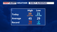
After a sunny Sunday afternoon with light westerly winds and high temperatures rising slightly above forecasts, the overnight hours will see lows plummet into the low to mid-20s. High clouds are expected to move in during the night, creating partly cloudy skies.
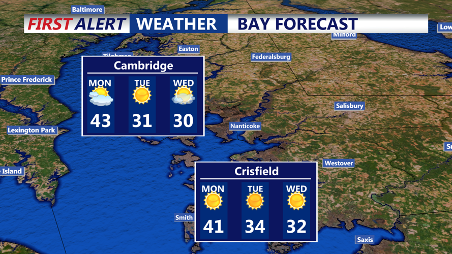
On Monday, a brief warming trend will bring highs into the upper 30s to low 40s under partly sunny skies. This respite will be short-lived, as a trailing arctic front associated with a low-pressure system moving through southern Canada is set to arrive Monday night. The front’s passage, though dry, will trigger a significant drop in temperatures as Canadian high pressure builds over the High Plains and extends into the region.
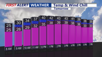
By Tuesday morning, Sussex County will experience lows in the teens and 20s, with daytime highs struggling to reach the freezing mark. Winds behind the front will intensify, with gusts of 30-40 mph expected. The resulting wind chills will hover in the teens during the day and dip into single digits to near zero overnight into Wednesday. Localized icy patches on untreated roads and bridges could pose hazards for commuters during these periods of extreme cold.
Residents are advised to dress in layers, avoid prolonged exposure to the cold, and monitor vehicles for winter readiness, as the cold spell is expected to persist through midweek. Local authorities may issue Cold Weather Advisories depending on the severity of wind chills in subsequent forecasts.
Looking ahead, the next significant chance of precipitation appears towards the weekend, as another weather system develops. Until then, Sussex County will remain under the grip of the arctic air mass.