


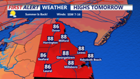
Showers and thunderstorms may move into Sussex County late Thursday before a warm, humid Friday with highs in the upper 80s.
From
To


Delmarva will see heat and humidity surge back into the region Saturday as a warm front lifts north, pushing temperatures near 90 degrees and sending heat indices above 100 in some areas. Spotty storms may develop during the afternoon, with a cold front arriving by Saturday night. The front is expected to stall near the region Sunday, offering some temporary relief from oppressive humidity. Another warm front and cold front combination early next week will bring additional chances for showers and storms before a more stable pattern returns midweek.


Delmarva’s weather pattern through the weekend and into next week will be dominated by a series of frontal boundaries bringing waves of warmth, humidity, and scattered thunderstorm chances. Friday begins cooler with cloud cover and a few showers, but a shift to a more southerly flow will increase temperatures through the weekend. The region could see highs in the 90s by early next week before another cold front arrives with a possible round of thunderstorms. Despite the unsettled pattern, extreme heat and widespread severe weather are not expected.


A Severe Thunderstorm Watch in place for all of Delaware until 10 p.m. Storms could produce damaging winds and hail. Coastal flooding is also a concern in Sussex County, where up to a foot of water may impact tidal roads and back bays due to an onshore flow and new moon. After the storms, a complex frontal pattern sets up through early next week, bringing shifting temperatures, intermittent rain chances, and elevated humidity levels before high pressure returns by midweek.


Sussex County will enjoy a brief reprieve from the heat Friday night into Saturday, but steamy conditions and dangerous heat index values are expected to return by Sunday and continue into early next week.


A stagnant and damp start on Tuesday will give way to summerlike heat and a growing threat of severe thunderstorms by Wednesday and Thursday across Sussex County.