


DELMARVA - A sluggish weather pattern marked by fog, drizzle, and scattered rain will finally start to shift Tuesday, setting the stage for a major transition in Sussex County — from damp and gray to hot and stormy by midweek.
Tuesday morning will begin on a dreary note throughout both coastal and inland Sussex County. A warm front will be making slow progress northward, lifting moisture into the region and keeping skies overcast with intermittent drizzle, light rain, and fog. Conditions will be particularly murky along the coast, including Rehoboth Beach, Lewes, Bethany, and Fenwick Island, where reduced visibility may linger well into the afternoon.
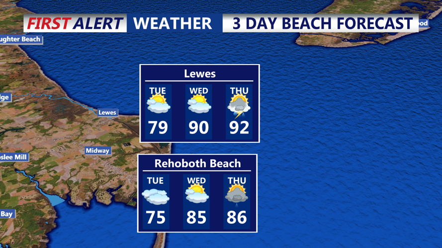
Temperatures in the morning will range from the low 60s at the beaches to the upper 60s inland, including communities like Laurel, Delmar, Seaford, and Georgetown.
As the front lifts farther north, inland areas will begin to break out of the clouds with some sunny intervals and warmer air. Highs inland could surge into the upper 70s to low 80s, while the beaches may struggle to climb past the low 70s under lingering marine influence.
With the warm front approaching and energy aloft moving through, expect a renewed round of scattered showers and thunderstorms, especially late Tuesday into the evening. These storms are not expected to be widespread or severe at this stage, but localized downpours and rumbles of thunder are possible.
Tuesday night will feel noticeably warmer and more humid, particularly inland. Overnight lows will stay in the upper 60s, with dew points remaining sticky. Showers and thunderstorms could redevelop during the night as the front fully passes through the region, laying the groundwork for a sultry Wednesday.
By Wednesday, southwest winds behind the front will usher in a full-on summertime air mass. Temperatures will soar to the mid to upper 80s inland, with dew points climbing into the 70s, creating heat index values in the mid to upper 90s for communities away from the coast.
Coastal areas will remain slightly cooler, topping out in the low to mid 80s, but the humidity will be felt there too.
The increased warmth and moisture will also help destabilize the atmosphere, setting the stage for scattered strong to severe thunderstorms by Wednesday afternoon and evening. These storms may be triggered by a surface trough and could bring:
Damaging wind gusts
Heavy downpours
Frequent lightning
The greatest threat for strong storms will be inland Sussex County, though beach communities may also see a storm or two if the activity extends eastward.
Early Thursday will continue the hot and humid theme, with temperatures starting in the 70s and dew points still elevated. A more potent cold front is expected to approach later Thursday, bringing the best chance yet for widespread storms, some of which could be severe.
Residents and visitors are advised to monitor weather alerts, especially for Wednesday afternoon through Thursday evening, as the severe storm risk increases across the Delmarva region.
