


A warm front will lift north through Sussex County Thursday night, followed by a humid Friday ahead of a slow-moving cold front that may bring scattered thunderstorms by Saturday.

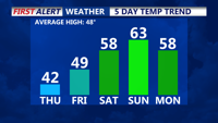
High pressure will dominate the Delmarva region today and tomorrow, delivering sunny skies and chilly temperatures in the low to mid-40s. Tonight, temperatures will dip into the mid to upper 20s under mostly clear skies. The weekend ushers in milder conditions, with highs climbing to the 50s on Saturday and low 60s by Sunday, accompanied by rain from back-to-back low-pressure systems. Early next week, unsettled and warm weather persists with another round of rain possible.


The week starts quiet on Delmarva, but an approaching low-pressure system could bring significant rain and tropical-like downpours by Tuesday afternoon and evening.

Friday will bring widespread heavy showers, embedded thunderstorms, and potential tornadoes to Delmarva as the remnants of Tropical Storm Debby merge with a frontal boundary.
A stalled frontal boundary near the I-95 corridor will influence weather conditions on the Delmarva Peninsula over the short term, bringing periods of rain and potential flash flooding.