


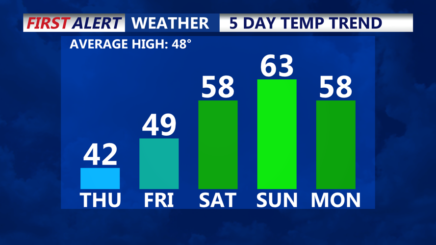


DELMARVA -- High pressure will linger over the Delmarva Peninsula through tomorrow, maintaining mostly sunny skies and below-normal temperatures. Today’s highs are forecasted to reach the low to mid-40s, making for a crisp and chilly December day. Tonight, mostly clear skies with light, variable winds will set up conditions for radiational cooling, dropping overnight lows into the mid to upper 20s in southern Delaware and across the Eastern Shore. However, incoming upper-level clouds late tonight may keep temperatures from dipping further.
Tomorrow brings partly cloudy skies and a slight warming trend as a low-pressure system over the southern Plains region begins to lift toward the Great Lakes. Daytime highs are expected to reach the upper 40s to near 50 degrees under partly cloudy skies.

Rain chances increase Saturday-New Year's
The weekend ushers in a significant shift as warm air advection intensifies, moderating temperatures and bringing unsettled weather. Saturday will remain cloudy, limiting the full warming potential, but highs will still climb into the mid to upper 50s. Overnight lows will be unusually mild, just a few degrees cooler than Saturday’s daytime highs.
On Sunday, temperatures will rise further, reaching the low 60s. Another low-pressure system trailing Saturday’s storm will bring widespread rain, particularly Sunday afternoon and evening. Rainfall chances are high, with precipitation probabilities ranging from 60% to 80%. Embedded thunderstorms are possible Sunday night ahead of an approaching cold front. While this scenario is rare for this time of year, gusty winds could accompany the storms due to a low CAPE/high shear environment.
Rain should taper off quickly Monday morning as the cold front moves through, providing a brief dry spell late Monday into New Year's Eve. However, the unsettled weather pattern continues with another upper-level trough expected late New Year's Eve night, keeping conditions warm and wet as the New Year approaches.
A big drop in temperature will arrive late next week as highs will be back in the mid to upper 30s.