


Delmarva will enjoy a pleasant start to the week with seasonable temperatures, lower humidity, and mainly sunny to partly cloudy skies through Tuesday. Minor coastal flooding is expected again with Monday evening’s high tide along the Atlantic coast and Delaware Bay. Heat and humidity return by midweek, with a chance for severe thunderstorms Thursday afternoon and evening before a fantastic Father’s Day weekend settles in.
From
To

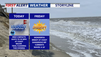
Hurricane Erin will make its closest pass to the Mid-Atlantic today, staying several hundred miles offshore but still delivering dangerous coastal conditions to Delaware and Maryland beaches. The storm is producing tropical-storm-force winds just off the coast, creating threats of beach erosion, life-threatening rip currents, and major tidal flooding along the Delaware shoreline. Conditions will improve tonight as Erin moves northeast, with fair and pleasant weather expected Friday and Saturday before another cold front brings unsettled conditions early next week.

Mild conditions will dominate early Tuesday, transitioning to fair weather with scattered light showers by Thursday as shifting fronts and troughs alter the scene.

High pressure will bring clear skies, below-normal temperatures, and a brisk northerly breeze to Delmarva through Thursday, making it feel more like late October.


A cold front crossing Delmarva will bring cooler temperatures, reduced humidity, and a stretch of pleasant weather from Thursday night through Friday night.