


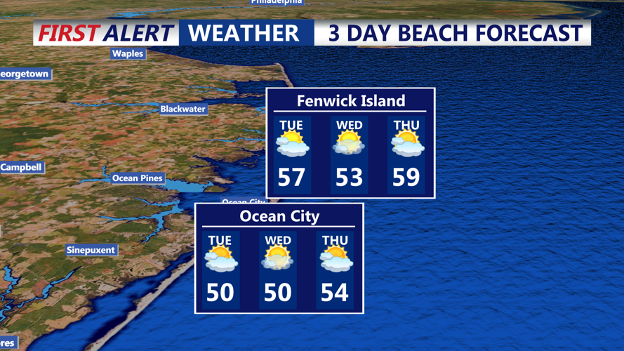
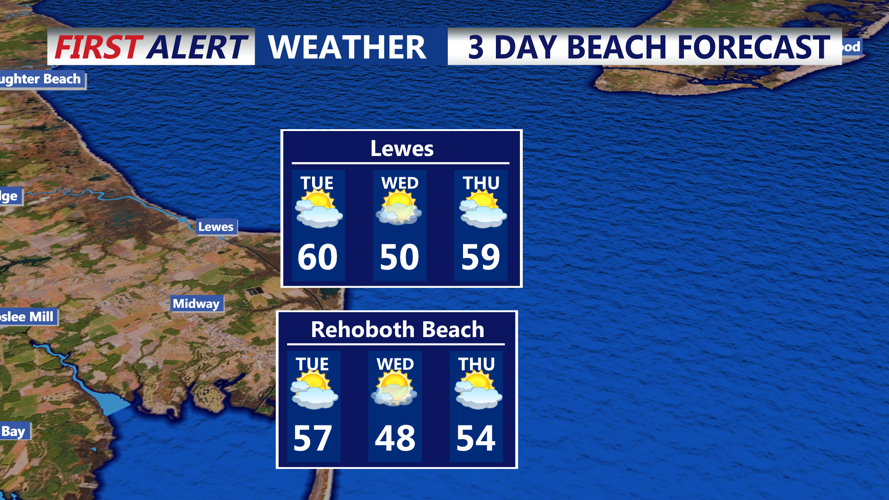


DELMARVA - Early Tuesday will begin under the steady influence of offshore high pressure, keeping conditions mild and inviting along Sussex county, Ocean City, and the surrounding beaches. Temperatures are expected to climb into the low to mid 50s, with coastal areas enjoying a gentle south to southwesterly breeze that may nudge readings closer to the upper 50s. A weak cold front moving through later in the afternoon will introduce a few scattered, light rain showers—primarily affecting areas northwest of I-95—while leaving most of the region largely undisturbed and comfortably above normal.
As Tuesday transitions into night, the weakening front will allow conditions to settle. Although lingering cloud cover may keep skies from fully clearing, the overnight cooling will be moderate, with temperatures gently dipping into the low to mid 30s. This calm interlude sets the stage for a pleasant Wednesday, where fair weather is expected to continue.
On Wednesday, the region will experience largely stable conditions with only a hint of change on the horizon. High pressure will keep the day mostly clear and mild, with temperatures moderating to the upper 40s in northern areas and reaching the low 50s along the coast. However, a developing trough from the Great Lakes will gradually signal a shift in the pattern, as its influence begins to materialize by the evening. This will keep the chance for rain minimal throughout the day while laying the groundwork for more active weather later.
By Thursday, the influence of the emerging trough will become more pronounced. As low pressure deepens and a stronger cold front sweeps through from the Great Lakes region, an increased chance of light showers will develop across the area. Rainfall amounts are expected to be modest, generally under a tenth of an inch for most locales, though slightly higher totals cannot be entirely ruled out in the northern sectors. While Thursday will maintain a mild overall feel, the passage of the front later in the day is anticipated to usher in a cooling trend, signaling a transition to noticeably cooler air as the week moves forward.
