


DELMARVA -- This afternoon, Hurricane Erin is making its closest approach to the Mid-Atlantic, staying roughly 300 to 400 miles southeast of Delmarva but producing significant coastal hazards across the region.

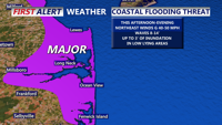
Major tidal flooding along the DE Coast through this evening, strong NE winds, high surf coinciding with high tide. Up to 3' inundation is possible.
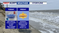
Erin’s growing wind field is pushing tropical-storm-force winds just off the Delaware and Maryland coasts, creating a mix of dangerous conditions for coastal communities. Strong northeast winds, sustained at 25 to 35 mph with gusts reaching 50 mph along the shore, are combining with high surf and high tide to produce major tidal flooding along the Delaware coast this evening. Beach erosion and life-threatening rip currents are also expected. A Wind Advisory remains in effect until midnight for the DE and MD/VA coasts.

Wind gusts at the coast will approach 50 MPH through this evening.
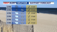
Away from the beaches, conditions are breezy but calmer. Inland areas are seeing overcast skies, northeast winds between 10 and 15 mph with gusts up to 25 to 35 mph, and temperatures holding in the low to mid-70s. Only spotty showers are expected from the outer bands of Erin, with dry conditions persisting for most of Delmarva.

Overcast and breezy away from the coast, gusts to 40 MPH, strongest winds will be at the coast through the evening.
Skies will begin to clear later tonight as Erin accelerates northeastward, with gusty winds diminishing and overnight lows falling into the low 50s to low 60s.
By Friday, weak high pressure will bring much-improved conditions, with highs climbing into the mid-80s under mostly sunny skies. Dry, pleasant weather will continue into Saturday, with seasonable temperatures and lower humidity before a stronger system approaches. Keep in mind waves will be 6 to 10 feet Friday with a dangerous risk of rip currents continuing into the weekend.
A cold front will move through late Sunday into Monday, bringing higher humidity and scattered showers or storms. While severe weather is not expected, some convection may linger into early Monday before cooler, drier air settles over Delmarva by midweek. Highs will fall into the 70s with lows in the 50s, delivering weather more typical of September than late August.