




Dry, windy conditions bring burn bans in Delaware and Worcester County, Maryland. Firefighters warn that even small sparks can quickly spread and cause serious damage.
From
To

Worcester County officials are warning that ongoing dry conditions have increased the risk of fast-spreading outdoor fires and are urging people to delay non-essential burning.

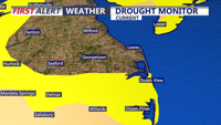
A mostly dry cold front Friday night will give way to cooler, drier and breezy conditions Saturday in Sussex County, increasing the risk of rapid fire spread.

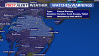
A cool and breezy Tuesday is ahead across Delmarva with afternoon highs in the mid 50s and northwest wind gusts of 30 to 35 mph. The combination of dry air and gusty winds will create an elevated risk for fire spread, though recent rainfall may help limit the overall threat. Colder air settles in tonight and lingers through Thursday morning, bringing freeze and frost concerns away from the immediate coast. After the chilly stretch, temperatures rebound quickly late week, with 70s returning by Friday and 80s possible early next week.

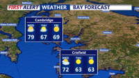
Warm conditions will continue across Delmarva on Wednesday, with temperatures climbing into the 70s and low 80s. Breezy southwesterly winds will increase ahead of an approaching cold front, which will bring cooler conditions by evening.

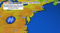
A high-pressure system will continue to dominate Delmarva's weather through the weekend and into next week, bringing clear skies, mild temperatures, and dry conditions. Tonight will be another chilly night with lows in the mid-30s to mid-40s, and patchy frost is possible in areas north and west. However, no frost advisories are needed as the growing season has ended in these areas. The severe drought in Sussex County remains a concern, with a high fire risk due to dry conditions. This weekend will feature sunny skies and pleasant temperatures, with highs reaching the low to mid-70s on Saturday and Sunday. Early next week, temperatures will rise even further, peaking near 80 on Monday, before a cold front brings cooler weather later in the week.

In response to ongoing drought conditions, Wicomico and Worcester counties have issued burn bans.