FILE - A person cools off at a cooling mist spot on a hot and sunny day at the Sensoji Buddhist temple in Tokyo's Asakusa district on Aug. 7, 2026. (AP Photo/Eugene Hoshiko, File)
FILE - A person cools off at a cooling mist spot on a hot and sunny day at the Sensoji Buddhist temple in Tokyo's Asakusa district on Aug. 7, 2026. (AP Photo/Eugene Hoshiko, File)

FILE - Tour operator Amanda Lovejoy wipes herself with a chilled towel in the heat Aug. 26, 2026, in the Hollywood section of Los Angeles. (AP Photo/Jae C. Hong, File)

FILE - Rickie Fowler wipes his face in the heat off the fifth tee box during the first round of the St. Jude Championship golf tournament Aug. 13, 2026, in Memphis, Tenn. (AP Photo/George Walker IV, File)

FILE - Visitors pass by the cooling fog device at Gwangmyeong Cave tourist site in Gwangmyeong, South Korea, Aug. 6, 2026. (AP Photo/Ahn Young-joon, File)
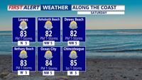
Very humid conditions will continue from Sussex County to Ocean City through Saturday, with isolated late-day storms capable of heavy rain and damaging wind gusts.
Temperatures will climb into the 90s Tuesday as Sussex County begins a stretch of hotter-than-normal weather.
One more day of showers and storms, then a drier Sunday.
Delmarva stays sunny, dry and hot today as high pressure keeps control of the forecast. Inland highs climb into the low to mid 90s, while the beaches stay cooler in the mid 80s. Heat and humidity build Saturday before a cold front brings isolated storm chances Sunday, especially across southern Delmarva.
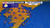
Delmarva will enjoy a mostly sunny and breezy day today with highs in the mid 70s and strong southerly gusts up to 35 to 40 mph. Showers arrive late this evening and continue overnight, with a few isolated thunderstorms possible, though severe weather is not expected. A brief unsettled stretch gives way to warmer, drier conditions by the weekend, with heat building into early next week.