


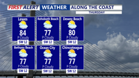


DELMARVA - Unseasonably warm weather from early Thursday morning through early Friday morning, with temperatures remaining far above normal and approaching record levels in some spots. Morning conditions Thursday will be mild, and the day is expected to turn quite warm by afternoon, with inland highs reaching the mid-80s to near 90 degrees, while communities closer to the coast remain somewhat cooler because of the influence of the ocean and a daytime sea breeze.
Although some high clouds may drift across the area Thursday, they are not expected to prevent another very warm day. The combination of warm air aloft and continued southerly flow will keep temperatures running well above average through the evening hours.
The main concern Thursday afternoon and evening will be elevated fire weather conditions. Dry air is expected to lower humidity values, while southwest winds of 10 to 15 mph and gusts up to 20 mph may allow any fires that develop to spread more quickly. Recent dry conditions have added to that concern, even though winds and humidity are not expected to reach official Red Flag Warning levels.
By early Friday morning, a weak front is expected to pass through the region. Even so, Sussex County is likely to remain mild, with temperatures staying above seasonal norms heading into the end of the week.
