


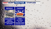
Starting Monday, Delmarva will enter a prolonged stretch of hot, humid, and stormy weather. The remnants of Tropical Storm Chantal will bring widespread showers and thunderstorms capable of downpours and localized flooding. Even the threat for severe storms Tuesday. As the week progresses, a stalled front and several disturbances will prolong unsettled conditions, with dangerous heat indices nearing 106 degrees and repeated rounds of storms expected into the weekend
From
To

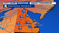
Onshore flow continues across Delmarva, maintaining mild temperatures and breezy conditions through Monday. High pressure will keep skies mostly clear with patchy fog in the mornings. A potential tropical system developing off the southeastern U.S. coast may bring increased rain chances by Tuesday into Wednesday, accompanied by rising humidity levels.

High pressure will bring calm and sunny conditions to Delmarva this weekend, with temperatures gradually returning to seasonal norms. By early next week, there is a chance of showers and thunderstorms as a new system approaches the region.


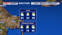
As the weekend starts, expect rising humidity and a growing chance of showers and thunderstorms, especially from Friday night into Saturday. Dangerous rip currents and surf are also anticipated due to the influence of distant Hurricane Ernesto.