


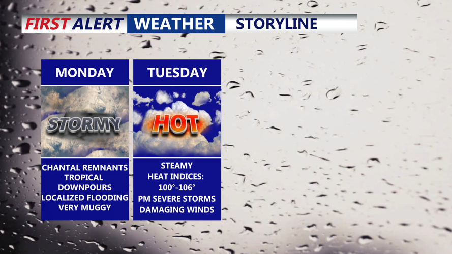


DELMARVA -- Humidity will sharply increase across Delmarva on Monday as Bermuda high pressure strengthens offshore. Moisture from the remnants of Tropical Storm Chantal will begin moving in by late morning, combining with several upper-level disturbances to create a favorable environment for showers and scattered thunderstorms.

Scattered tropical downpours develop in the afternoon-evening.
Expect the rain coverage to ramp up through the afternoon, with locally heavy downpours leading to small pockets of flooding. While rainfall totals will generally range from one to two inches, some locations may exceed two inches before storms move out. Gusty winds are possible with any stronger storms, and isolated severe weather cannot be ruled out. Daytime highs will reach the 80s in most areas, though a few inland spots may briefly push into the 90s before storms arrive.

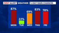
Remnants of Chantal Monday, cold front stalls out of the region Tuesday bring shower and storm threats into late week.
The pattern remains active Tuesday as a cold front drops slowly south. This boundary will stall across southern portions of the region by Tuesday night, acting as a focus for renewed storm development.
Temperatures will again climb into the mid-80s to mid-90s, with dew points in the 70s creating stifling conditions. Forecast heat index values are expected to peak between 100 and 106 degrees across much of Delmarva.
The tropical air mass combined with strong daytime heating will support growing instability. Showers and thunderstorms will increase in coverage through the day, some capable of producing damaging wind gusts and brief flooding. The region has been placed in a Marginal Risk (Level 1 of 5) for severe thunderstorms and a Marginal Risk (Level 1 of 4) for excessive rainfall. Forecast soundings highlight the potential for very efficient rainfall-producing storms, with precipitable water values exceeding 2 inches at times and a profile supportive of training cells that repeatedly impact the same areas.

Storm Prediction Center has placed the entire Delmarva peninsula under a "Marginal" (1 of 5) risk, damaging winds/downbursts & flash flooding.
By Tuesday night, storm coverage will diminish somewhat as daytime heating wanes, though a few isolated showers and rumbles of thunder may linger overnight. The stalled front will continue to hang over the region into midweek, maintaining a humid and unsettled pattern.
Rainfall from Monday through Wednesday morning will be 1 to 2 inches with locally higher amounts of 3 to 4 inches where heavier/training storms occur.

From Monday to Wednesday morning some areas can pickup over 2 inches of rainfall. Localized flash flooding is possible.
On Wednesday, isolated to scattered thunderstorms are again expected, especially near the lingering boundary draped close to Delmarva. Additional weak disturbances are forecast to track through Thursday and Friday, fueling more rounds of showers and storms each afternoon. Another disturbance is likely Saturday, prolonging the unsettled weather.

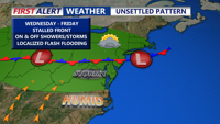
Stalled frontal boundary Wednesday-Friday brings the chance for on and off showers and storms.
High temperatures from Wednesday into the weekend will mostly hold in the 80s, but persistent high dew points in the 60s and 70s will maintain muggy, oppressive conditions.