


A stalled front and weak low pressure system will keep clouds and scattered showers over Delmarva Sunday, with highs only in the low to mid-70s. Conditions improve Sunday night as high pressure builds in, bringing dry and seasonable weather to start the week. A weak coastal low could bring more clouds midweek, while a warm, dry Thursday is followed by another cool and comfortable weekend.
From
To

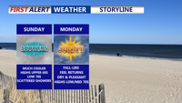
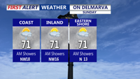
Clouds and scattered showers linger across Delmarva Sunday as a nearly stationary front and weak low pressure system pass through the region. Highs will remain cool, in the low 70s, before conditions clear late in the day. Dry weather and seasonable temperatures return Sunday night into Monday, with partly sunny skies and highs in the mid-70s. A weak coastal low could increase cloud cover Tuesday into Wednesday, followed by a stretch of dry, pleasant weather for the latter half of the week.

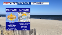
Monday will bring sunny skies and highs in the low 80s with comfortable humidity across Delmarva. However, haze from Canadian wildfire smoke may filter the afternoon sunshine. Delaware is under a Code Orange Air Quality Alert, posing health risks to sensitive groups, and there’s a moderate rip current risk at area beaches. Tranquil and dry weather continues into Tuesday before cloud cover increases midweek with near-normal temperatures and a slight chance of showers later in the week. Watching the coast late week for a potential develop coastal low.


A comfortable night is ahead for Delmarva with clear skies and lows in the upper 50s inland and mid to upper 60s at the coast. Monday will be sunny and warm with highs in the low 80s, though haze from Canadian wildfire smoke may filter sunshine. Delaware is under a Code Orange Air Quality Alert for sensitive groups, and a moderate risk of rip currents is posted for area beaches. Tranquil weather continues into midweek with increasing clouds and near-normal temperatures.