


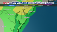
Delmarva faces an unsettled Sunday with showers and thunderstorms, some potentially severe with damaging winds and localized flash flooding. A warm front moves through ahead of a weak cold front Sunday night, followed by a hot and humid start to the week before a stronger midweek cold front brings relief heading into next weekend.
From
To

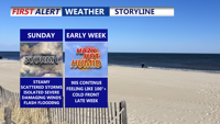
A warm front lifting into Delmarva Saturday night will bring clouds, muggy conditions, and a chance for storms, some of which could be strong with gusty winds. Sunday will feature periods of showers and thunderstorms before skies clear Monday, leading into a hot and humid start to the week. A midweek cold front promises relief by Friday and next weekend.

Will enjoy a brief thaw as the final week of January begins with seasonable temperatures and mostly dry conditions. A strong cold front midweek will usher in colder air and arctic high pressure, followed by a potentially complex system bringing precipitation into the weekend.

A weekend of improving weather conditions, today brings partly cloudy and slightly milder temperatures. However, gusty northwest winds will keep things feeling brisk. A dry stretch will persist from Saturday night through early next week, with mild highs in the mid-to-upper 50s and seasonably cool nights. A cold front midweek will introduce cooler air by Wednesday, with the possibility of rain later in the week.

A ridge of high pressure will keep Delmarva dry and mild through Monday, with warmer temperatures on the way as a southerly flow develops. Highs will reach the low to mid-60s, making for a pleasant start to the week, but changes are ahead with a cold front arriving midweek.