


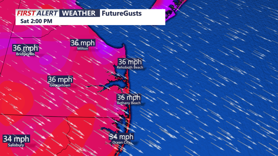


DELMARVA -- The low-pressure system that brought unsettled weather to the region will move into the Canadian Maritimes today, allowing conditions to improve across Delmarva. Expect partly cloudy skies, high temperatures will rebound by around 10 degrees compared to Friday, reaching low to mid 50s. However, strong northwest winds of 15 to 20 mph, with gusts up to 30-40 mph, will make it feel cooler.

Week Planner
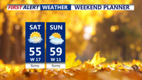
A dry period begins tonight and continues into Monday as a surface ridge builds over the Mid-Atlantic. Skies will remain partly to mostly sunny both days. Highs on Sunday and Monday will climb into the mid-to-upper 50s—slightly above average for this time of year. Overnight lows Sunday night will range from the upper 30s to low 40s in urban areas and low-to-mid 30s in rural spots, making for a chilly but calm evening.
Looking ahead, a cold front will bring changes early next week. Monday night temperatures will stay relatively mild, with lows in the 40s and some upper 30s in far northwestern areas. Dry weather will persist through Tuesday as high pressure dominates, keeping highs slightly above average in the low-to-mid 50s. By Wednesday, colder air will settle in, with daytime highs dropping into the upper 40s to low 50s.

Thanksgiving - Black Friday Coastal Storm Possible
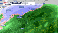
Clouds will increase Wednesday night as a new low-pressure system develops over the Ohio Valley and tracks eastward. This system is expected to bring rain to Delmarva on Thanksgiving and Thanksgiving night. Current indications suggest this will be a rain event, but areas farther north, like the southern Poconos, could see snow. The low may intensify offshore, potentially extending precipitation into Friday.