


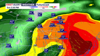
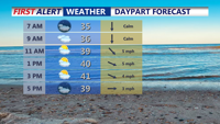
Showers and scattered thunderstorms are expected to continue this afternoon. There is a low chance of damaging winds with some storms.
From
To


Winds continue to diminish this evening and overnight. Skies partially clear with lows in the 30s by morning.

Temperatures above freezing much of the week with light snow from clipper systems.

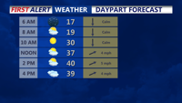
Watch for dense fog in spots this morning, causing slick roads and bridge decks, with temperatures into the 20s to near 30.

Areas of dense fog overnight, then more clouds than sun for Sunday and chilly. Then much colder early next week.

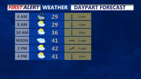
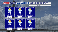
More clouds than sun this weekend and chilly. Then much colder early next week.


DELMARVA- High pressure continues to slide off the coast today, ushering in warmer air and breezy conditions. A Yellow Alert is in effect for …


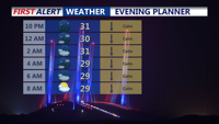
High pressure continues to slide off the coast overnight into Sunday, ushering in warmer air and breezy conditions. A Yellow Alert is in effect for Monday morning for strong winds and heavy rain.

Unsettled weather for the weekend with more clouds than sun and frequent showers.

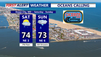
Sunday’s weather will be similar to Saturday's, with high pressure drifting slightly southeast. This will maintain an onshore flow and the possibility of an isolated shower near the coast.