


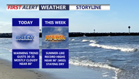
Today brings a pleasant and mild start to the week across Delmarva with mostly cloudy skies, breezy southwest winds, and highs near 80 inland, while beach communities stay in the mid to upper 70s. A weak disturbance could spark an isolated light shower, mainly north and west of the peninsula. Warmer air then builds in through midweek and into the weekend, sending temperatures 15 to 30 degrees above average with some inland spots potentially reaching 90 degrees for the first time this year.
From
To

Strong winds and cold temperatures persist Tuesday before easing overnight into early Wednesday in Sussex County.

A strong cold front ushers in damaging wind gusts and frigid temperatures through Tuesday evening in Sussex County.

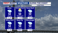
Mostly cloudy skies and near-normal temperatures are expected from late Wednesday evening through late Thursday evening, with only a small chance of brief flurries or sprinkles, especially on Christmas Day.

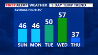
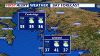
High pressure over the Southeast will bring seasonable temperatures and mostly dry conditions to Delmarva starting today. Temperatures will rise into the 50s by midweek as a January thaw sets in, but a stronger cold front late Wednesday will bring colder air by the week's end. Winds will gust up to 25 mph today, with highs in the mid to upper 40s. A brief dip in temperatures follows Thursday and Friday, with highs in the 20s and 30s before moderating slightly by Saturday.