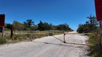
Drive-on surf fishing crossings at Cape Henlopen State Park, Delaware Seashore State Park, and Fenwick Island State Park will close at 6 p.m. due to incoming weather and high surf.
Drive-on surf fishing crossings at Cape Henlopen State Park, Delaware Seashore State Park, and Fenwick Island State Park will close at 6 p.m. due to incoming weather and high surf.
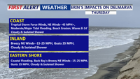
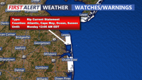
Hurricane Erin will pass offshore this week, but its growing size is already producing dangerous waves and life-threatening rip currents along Delmarva beaches. Tropical Storm Warnings remain in effect from the coastal waters of Cape Henlopen to Chincoteague, with strong winds and minor to moderate tidal flooding expected Thursday. Conditions begin to ease by Friday as high pressure builds in.
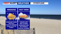
Delmarva will enjoy a warm but not overly hot Saturday, with highs in the 80s inland and 70s to low 80s along the coast. Humidity will remain elevated ahead of a Sunday cold front, which could bring an isolated shower late Sunday-early Monday. Cooler, drier conditions are expected early next week, we continue to monitor Hurricane Erin for possible coastal impacts starting Monday.

Rehoboth Beach officials announced on Monday that ocean access has been temporarily closed due to rough surf conditions and the city confirms reportings of medical waste ashore.
Today will bring warm temperatures and dry conditions to the Delmarva region as a high-pressure system keeps rain at bay. However, a shift in weather is expected as the weekend approaches, with showers and thunderstorms becoming more likely, particularly on Sunday. Dangerous rip currents and surf will develop this weekend. A cooler, less humid air mass will arrive early next week, bringing relief after the weekend's unsettled weather.