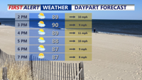
Sunday will be hot and humid across Delmarva with temperatures rising into the upper 80s and low 90s and heat index values between 100 and 104 degrees. A cold front approaching from the northwest could trigger isolated storms late in the day, some of which may become severe. After the front moves through, high pressure will bring more comfortable and dry conditions through Wednesday before heat and humidity return late in the week.
From
To

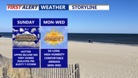
Delmarva will swelter under heat and humidity Sunday, with temperatures climbing into the upper 80s and low 90s, and heat index values reaching 100–104 degrees. A cold front moving through the region could trigger isolated strong to severe storms late in the day, though widespread storm activity remains limited. High pressure builds in early this week, bringing drier and more comfortable conditions through Wednesday before heat and humidity make a comeback toward the end of the week.


Saturday brought tropical downpours and flash flooding to parts of Delmarva, especially in Worcester County. While not everyone saw rain, Ocean City and Berlin were inundated with 3 to 4 inches of rainfall in just a few hours. A muggy night with lingering showers will be followed by heat and the threat of isolated severe storms Sunday. A cold front is expected to bring relief into early next week before humidity builds again by the end of the week.

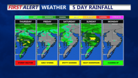
Thursday will bring showers and possible severe storms to Delmarva, Coastal Sussex County, and Southern Coastal Delaware, with cooler temperatures and continued precipitation through Friday.