


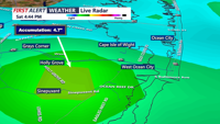


DELMARVA -- It was a gloomy Saturday, with tropical conditions across the area, with scattered showers and heavy downpours. While some communities remained dry, parts of Worcester County, particularly Ocean City and Berlin, experienced flash flooding after receiving 3 to 4 inches of rain within just a few hours.

Close to 5 inches of rain fell this afternoon with flash flood warned storms in Worcester County.
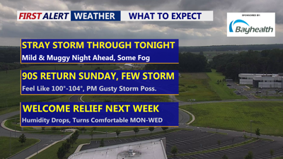
As the evening progresses, residents can expect a muggy night with temperatures settling into the mid-70s. While a stray shower or downpour can’t be ruled out, conditions will largely quiet down ahead of an active and sweltering Sunday.

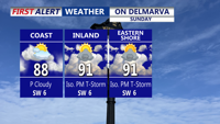
Hot and humid Sunday, feeling like 100 to 103, late gusty isolated storm possible.
A cold front is poised to move into the region by Sunday afternoon. Highs will soar into the upper 80s to low 90s, with heat indices climbing to 100–104 degrees thanks to dew points in the low-to-mid 70s. The Storm Prediction Center has placed the area under a "Marginal" (1 out of 5) risk for severe weather, including damaging winds, hail, and localized flash flooding.

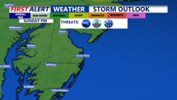
Storm Prediction Center has a "Marginal" ( 1 of 5) risk Sunday, threat of damaging winds, hail and flash flooding.
A mid-level disturbance currently tracking east from the Ohio Valley. It is expected to pass overnight into Sunday morning, potentially suppressing early convective development. However, with ample daytime heating and unstable air, storms could organize later in the day.
Any storms that form could be capable of gusty winds, hail, and brief but intense rainfall. Fortunately, the fast-moving nature of the front should help minimize widespread flooding concerns, though isolated flash flooding remains possible.
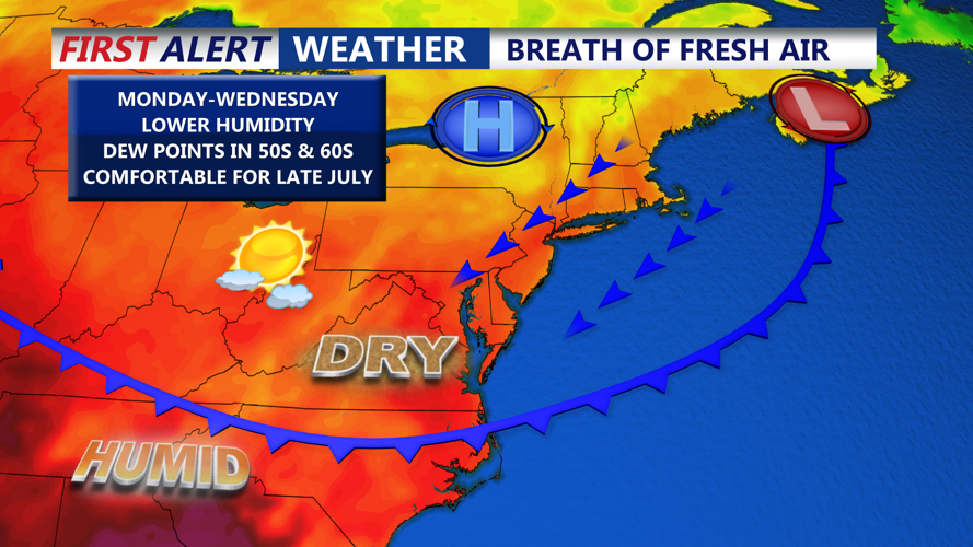
By Sunday night, storms will taper off as the cold front pushes east of the I-95 corridor. In its wake, cooler and drier air will usher in a much more comfortable pattern through Tuesday, with dew points dropping into the 50s and 60s and highs in the low to mid 80s.

Cold front brings comfortable air Monday-Wednesday, humidity levels drop.
Looking ahead, high pressure will dominate into Wednesday, but by Thursday, southwesterly flow returns. Expect rising heat and humidity, with Friday likely feeling oppressively muggy and heat index values again pushing past 100 degrees. Another cold front is expected to approach by late next week, bringing renewed chances for storms, although the exact timing remains uncertain.
