


Today on Delmarva, a powerful storm system will bring the risk of strong to severe thunderstorms this afternoon into tonight, with damaging winds as the primary concern and an increasing threat for isolated tornadoes. Even outside of storms, southerly winds will gust from 35 to 45 mph, with some areas seeing gusts up to 50 mph. Heavy rainfall may lead to localized flash flooding, especially inland, while Sussex County faces minor coastal flooding along the back bays including Rehoboth Bay and Little Assawoman Bay. Conditions turn cooler and dry Tuesday through Wednesday before temperatures gradually moderate later in the week, with the next chance for showers arriving Friday night into Saturday.
From
To


A stagnant and damp start on Tuesday will give way to summerlike heat and a growing threat of severe thunderstorms by Wednesday and Thursday across Sussex County.

Delmarva faces a marginal risk for severe storms Sunday afternoon and evening as a frontal boundary stalls over the region. Showers and thunderstorms—some potentially strong with damaging winds and isolated tornadoes—could impact parts of the peninsula, especially the southwest. Quieter weather returns Monday before another round of rain and storms arrives Tuesday. The second half of the week turns drier and significantly warmer, with highs reaching the 80s and possibly nearing 90.

From early Thursday through late Sunday, Sussex County will see a mix of clearing skies, brief warmups, scattered storms, and a cooler, breezy finish to the weekend.


Wicked weather, school board elections, unhappy homeowners and more, it was a jam-packed week here along the coast, here is your Week in Review.


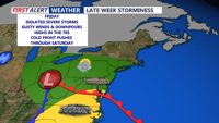
A strong cold front could bring severe storms to Delaware’s beach towns and Ocean City late Monday, followed by much cooler and drier conditions Tuesday into Wednesday.