


DELMARVA - Delaware’s beach towns and Ocean City, Maryland, are under the threat of strong to severe thunderstorms beginning late Monday afternoon and continuing through Monday night, ahead of an approaching cold front.
According to the National Weather Service, atmospheric conditions are becoming increasingly unstable across the region Monday afternoon, with enough fuel for thunderstorms to turn severe. Skies have cleared earlier than expected, allowing temperatures to climb into the 70s—several degrees above forecast—boosting the potential for damaging storms later in the day.
The primary threat will be damaging wind gusts, though an isolated tornado cannot be ruled out. The Storm Prediction Center has placed the region under a slight risk for severe weather. The most active period for storm development appears to be from 3 to 9 p.m., with storms beginning as isolated cells before forming a more organized line after sunset.
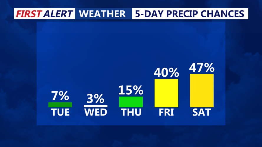
Rainfall amounts of 1 to 2 inches are possible, raising concerns for flash flooding despite ongoing drought conditions. Rain should taper off overnight as the front clears the area, with lingering showers possible early Tuesday morning.
By Tuesday, cooler and drier air settles in, with high temperatures expected in the mid to upper 50s. Breezy northwest winds will gust up to 25 mph through the day. Skies will remain sunny, but it’ll feel noticeably cooler compared to Monday.
Overnight lows Tuesday into Wednesday morning could dip into the upper 30s for coastal areas, but frost is not expected due to persistent light winds. Another cool and breezy day is in store for Wednesday, with highs again in the low to mid 50s. Winds will shift more easterly and southeastward late in the day, setting up for a gradual warming trend by Thursday.
