


DELMARVA - Thursday will start off damp with lingering drizzle or spotty light rain early in the morning, especially near the coast. As a departing coastal low moves farther north, winds will shift west and northwest, allowing drier air to push in. By midday, skies will begin to clear across Sussex County, with some sunshine breaking through during the afternoon. Temperatures will warm nicely into the low to mid 70s, even at the beaches, thanks to the offshore wind. The rest of the day will remain mostly dry, with only a slight chance of a stray shower as lingering moisture interacts with daytime heating.
THURSDAY NIGHT:
A new cold front will move across the Delmarva region overnight. Expect increasing clouds and a chance of scattered showers and thunderstorms, especially after midnight. Temperatures will drop into the upper 50s to low 60s by morning.
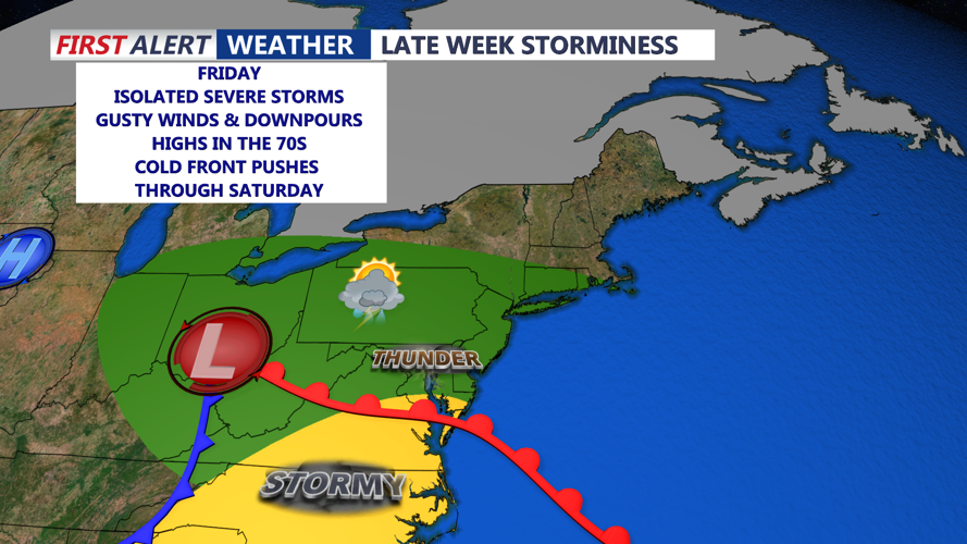
FRIDAY:
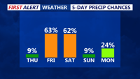
Friday will be unsettled, as the cold front stalls over or just north of Sussex County. A low-pressure system forming along the boundary will enhance rain chances later in the day. Expect rounds of showers and possible thunderstorms through the afternoon and evening. The Storm Prediction Center currently outlines a marginal risk for severe storms across southern Delaware, meaning isolated strong to severe thunderstorms are possible. Some storms may bring gusty winds and brief heavy rain. Highs will reach the low to mid 70s. Overnight lows will fall to the upper 50s.
SATURDAY:
Another, stronger cold front will arrive Saturday afternoon. Widespread showers and thunderstorms are likely again—potentially strong—though official severe weather outlooks have not yet been issued. Highs will be in the low 70s before the front passes. Once the front clears the region Saturday evening, winds will turn sharply to the northwest, ushering in a much drier and cooler air mass. Overnight lows will fall into the 40s and low 50s, with a noticeably breezy night expected.
SUNDAY:
Sunday brings much-improved conditions. With high pressure building in from the west, skies will clear, though a few stray showers are possible north and west of Sussex County. Expect partly sunny skies and cooler temperatures, with highs in the low to mid 60s. Breezy northwest winds will persist throughout the day, bringing a crisp, fall-like feel to the end of the weekend. Overnight lows will dip into the mid to upper 40s inland, and the low 50s along the coast.