


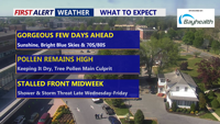
After days of rain and wind, sunshine has returned to Delmarva. A dry cold front will sweep through the region today, bringing gusty northwest winds and cooler air. High pressure will settle in through the end of the week, keeping skies clear and temperatures seasonable before a warming trend and rain chances arrive by Sunday into Monday.
From
To

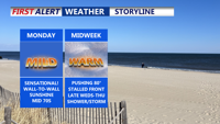
Delmarva will kick off the week with above-normal temperatures and increasing breezes. A warm front on Tuesday and a cold front on Wednesday could bring some scattered showers, but dry and mild weather is expected to return for the weekend.

Delmarva will experience clear, cool conditions Sunday night with temperatures dipping into the 40s. As high pressure shifts eastward, a warm front will bring above-normal temperatures and breezy conditions through midweek. A cold front arrives by Wednesday, bringing a chance for showers before clearing out for a cooler, drier weekend.


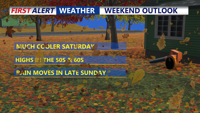
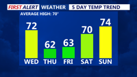
High pressure will keep Delmarva dry and seasonably cool through Saturday, with clear skies tonight and sunny but noticeably colder conditions tomorrow. A shift in the weather pattern begins Sunday as a warm front lifts north, bringing increasing clouds and rain by late Sunday into Monday morning. Temperatures will remain cool early in the weekend but will warm slightly into Monday.