


DELMARVA -- High pressure centered over the Great Lakes will continue building into Delmarva Sunday night, setting the stage for clear skies and light winds. Overnight temperatures are expected to fall into the low to mid-40s across much of the region, a few degrees below average for late April.

Feeling more like summer over the next week.
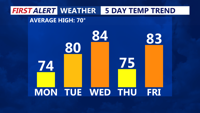
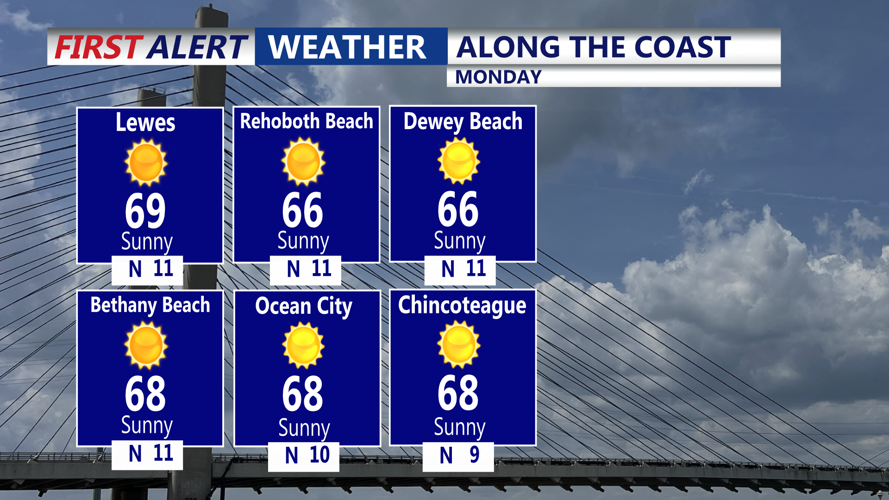
By Monday, winds will turn variable in the morning before shifting to a southwest flow by afternoon, with sea breezes pushing inland toward the I-95 corridor. Inland areas can expect southwest winds around 5 to 10 mph. Temperatures will rebound nicely, reaching the low to mid-70s, several degrees above seasonal norms.

Sunshine with highs in the 60s to near 70 along the coast.
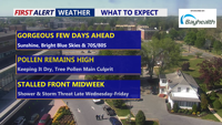
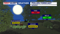
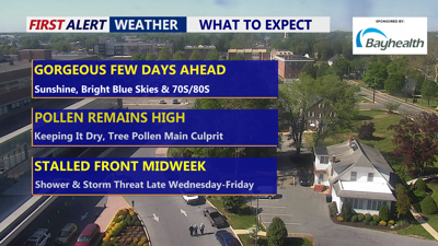
Pollen will continue to remain HIGH, particular the tree pollen, grass pollen creeping up to a moderate level as we keep things relatively dry on Delmarva.

High tree pollen and moderate grass pollen into Monday.
The warmup continues Monday night as an upper-level ridge builds overhead. Clear skies early will give way to increasing clouds late as a frontal system approaches. Lows will range from the mid-40s to low 50s. Tuesday will bring stronger southerly breezes, potentially gusting up to 25 mph, pushing daytime highs into the mid-70s to low 80s. Moisture levels will rise, making Tuesday night much milder with lows only falling into the 50s. There is also a chance for some scattered showers Tuesday night ahead of a cold front.
On Wednesday, the cold front will cross much of the area, stalling near or just south of Delmarva. While the air behind the front won't be particularly chilly, it will bring drier conditions with a west-northwest breeze. Highs will still climb into the mid-70s to low 80s across most of the region.
Looking ahead to Wednesday night and Thursday, the stalled front may lift back north as a warm front, but rain chances remain low. High pressure will briefly build north of the region Thursday, keeping skies generally dry with highs ranging from the upper 60s to upper 70s.
By Thursday night and Friday, a stronger system will approach from the west. Showers are possible late Thursday into Friday, with a better chance for rain and possibly some thunderstorms as a cold front moves through Friday night. Temperatures will remain warm Friday with highs in the upper 70s to mid-80s.
Heading into the weekend, Saturday will usher in drier and cooler air, returning temperatures closer to normal with highs mainly in the 60s and 70s under mostly dry skies.