


The powerful ocean storm continues to move away from the east coast with diminishing impacts.
From
To

The main effects from the powerful off shore storm will be the wind, dangerous wind chills, and minor tidal flooding.

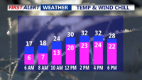
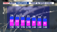
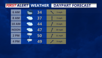
Tonight brings yet another frigid, frosty night across the peninsula. Temperatures will tumble into the single digits, ranging from about 4 to 12 degrees by daybreak Saturday.

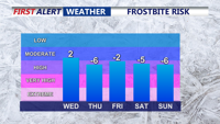
Delmarva is heading into a prolonged stretch of dangerous, bone-chilling cold, as an Arctic air mass locks in for the remainder of the week and may linger into the weekend.


Conditions remain dry into the evening, with partly cloudy skies and overnight lows dropping into the low to mid 20s by Saturday morning.


Conditions remain dry into the evening, with partly cloudy skies and overnight lows dropping into the low to mid 20s by Saturday morning.

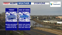
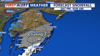
A bit warmer and breezy for the rest of Wednesday, then colder again to end the week. Some snow possible on Sunday.

A cloudier end to the weekend with Sunday showers, then a coastal low brings a cold rain and wind on Tuesday with a Yellow Alert.


DelDOT has installed four new weather-monitoring stations designed to detect rising water in real time.

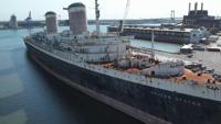
The SS United States is set to leave the South Philadelphia dock and begin her transformation into the world’s largest artificial reef after two failed attempts.