DELMARVA - Delmarva is heading into a prolonged stretch of dangerous, bone-chilling cold, as an Arctic air mass locks in for the remainder of the week and may linger into the weekend. Even with mostly sunny skies at times, this will be a cold that demands extra caution, especially for anyone spending extended time outdoors.

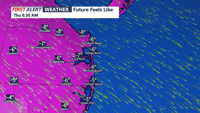
Afternoon highs reach roughly 25 to 32 degrees, but it will feel a lot colder with the wind, wind chills hover around 13 to 19 degrees, making it feel far colder than the thermometer suggests.

Another reinforcing surge of arctic air arrives as a moisture-starved cold front moves through. While most areas stay dry, a flurry or brief snow shower is possible. Overnight lows fall to 7 to 13 degrees, and by Wednesday morning, wind chills could dip to around 3 below zero in the coldest spots.

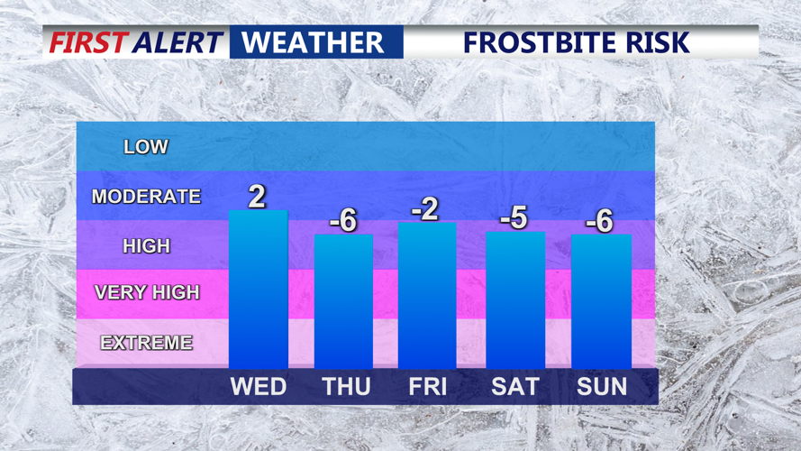
High temperatures Wednesday only climb into the mid-20s under partly cloudy skies. The bigger concern comes at night. From Wednesday night through Friday night, Delmarva faces overnight lows in the low single digits to below zero, depending on location. Add in a steady breeze, and wind chills drop well below zero, potentially as low as 7 to 10 below zero. This is the kind of cold that can cause frostbite and hypothermia within minutes without proper layers and protection.

This combination of duration and intensity is exceptionally rare for Delmarva and could create impacts beyond personal discomfort—especially stress on energy infrastructure, higher heating demand, and increased risk of frozen pipes.

We are also monitoring the potential for a coastal storm late Saturday into Sunday. Confidence on exact impacts is still low, but there is concern the system could track close enough to affect Delmarva. If the storm comes together nearby, conditions would be cold enough to support snow.

For Delmarva, the latest guidance suggests the highest snow potential near the immediate coast, with lower probabilities farther inland. Current snowfall probabilities for 4 inches or more are highest closest to the shoreline. Even if the storm tracks offshore, strong winds could still create problems along the coast, including beach erosion and tidal flooding.

The bitter cold is the sure thing, and it stays very cold through the weekend into early next week. Keep checking updates as the weekend storm track becomes clearer.


Meteorologist

Meteorologist Bob Trihy joined CoastTV in 2023. He grew up in Great River on Long Island, N.Y. Bob caught the weather bug when he was around eight years old and tracked storms up and down the east coast. He witnessed some big ones, like the blizzard of 1978, as well as tropical systems.

Recommended for you