


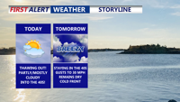
Delmarva warms up today as a warm front lifts through, pushing highs into the mid to upper 40s with partly to mostly cloudy skies. A light southerly breeze increases tonight with a small chance of a stray sprinkle, but most spots stay dry and above freezing. Wednesday stays in the 40s but turns noticeably breezy ahead of a moisture-starved cold front. Cooler, breezy conditions follow Thursday and Friday, then Valentine’s Day kicks off the weekend with sunshine and a springlike feel. Late Sunday into early Monday, a storm system could bring precipitation—details still uncertain this far out.
From
To

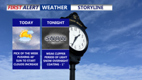
Today is the best day of the week across Delmarva, with highs in the upper 30s to low 40s before clouds thicken late. A weak clipper brings a quick hit of light snow after midnight, ending by daybreak Wednesday with an inch or less. The bigger story late week into the weekend is a surge of Arctic air—dangerously cold wind chills and another round of light snow or snow squalls possible Friday.

Delmarva will see clearing skies on Monday following a frontal passage, with mild temperatures and a light breeze. High pressure will maintain calm and dry weather Monday night into Tuesday morning, though some light showers could develop by late Tuesday night as a warm front approaches.

Delmarva will experience increasing cloudiness late Sunday into early Monday as a frontal boundary moves through the region. Skies will clear Monday afternoon, with temperatures warming into the 60s and breezy northwest winds developing.

A strong cold front will sweep through Delmarva early Monday, bringing cooler temperatures, gusty winds, and partly cloudy skies through the day and into Tuesday.