


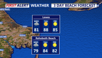
A warm front may bring scattered showers and thunderstorms to Sussex County late Tuesday night through Wednesday evening.
From
To

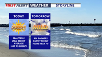
Delmarva will feel much cooler today, with temperatures running 25 to 30 degrees lower than yesterday. Scattered showers will taper off late this afternoon into the early evening, while gusty northeast winds make it feel raw. Sunshine returns Tuesday, followed by warmer, windier weather Wednesday with showers and a few thunderstorms possible. A drier and much warmer pattern is expected by the weekend, bringing a taste of summer with highs climbing into the upper 80s to low 90s.

A limited fire weather risk continues into Tuesday evening for inland Sussex County before showers arrive Wednesday with little severe weather threat.

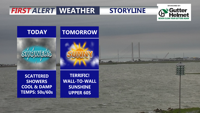
Delmarva started the day with a cold morning, with many spots away from the coast in the 20s, but sunshine and lighter winds will help temperatures recover into the mid to upper 50s and near 60 this afternoon. Milder air builds in tonight and Wednesday, with highs surging into the upper 60s and low 70s. Even warmer weather arrives Thursday and Friday before a cooler pattern and the chance for beneficial widespread rain return this weekend.

Heavy showers and thunderstorms will taper off Wednesday, giving way to clearing skies and calmer weather through early Friday.


A mix of fog, showers, and isolated thunderstorms will affect coastal Sussex County from early Tuesday into Wednesday night, with some clearing expected midweek before another round of unsettled weather.