


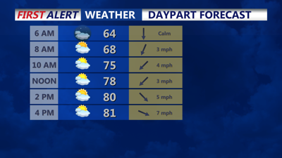


DELMARVA -- You can expect a comfortable start to the week as surface high pressure remains in control on Tuesday. Although a departing upper-level trough could lead to the development of fair weather cumulus clouds in the afternoon. Winds shifting to the northwest will bring even cooler temperatures, with highs only reaching the low 80s across the region, and slightly cooler conditions along the coast, where temperatures will hover in the mid to upper 70s.
Weak surface high pressure will continue to influence Delmarva through mid-week. While upper-level disturbances will pass through the region, the high pressure should keep the weather mostly dry. However, isolated showers or thunderstorms could develop on Wednesday and Thursday afternoons, primarily due to interactions between the sea breeze and upper-level troughs. Temperatures during this period will see a slight increase, with afternoon highs nudging upwards, offering slightly warmer conditions.
As we head into the weekend, the weather pattern becomes more uncertain. The weak surface high pressure over Delmarva on Thursday night into Friday will likely shift offshore as a developing cyclone and associated frontal boundaries approach from the west. This system could impact the region from late Friday through the weekend into Monday. However, the timing and specifics of this system remain uncertain, with varying predictions on the strength and speed of the low-pressure system. For now, expect a dry start to Friday, with increasing chances of rain later in the day and continuing into the weekend. Temperatures will remain around average for this time of year.