


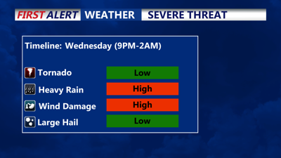


DELMARVA - Another stifling afternoon with temperatures in the mid 90s and oppressive heat indices from 104 to 112 degrees, although our heatwave will break with a severe storm threat Wednesday evening, some storms could pack damaging winds to 70mph and torrential rain.
Wednesday night, a line of storms should move into Delmarva between 8 p.m. to 10 p.m. this evening, moving west to east, getting to the coast by around 11 p.m. to 12 a.m. Some of these storms could go severe, packing damaging winds of 70mph with blinding downpours. Be sure to stay weather aware this evening into the overnight. It will continue to stay humid with lows dipping into the mid 70s.
Thursday will feature partly sunny skies and highs only in the mid 80s, however we keep a threat for scattered showers and storms as the front stalls off the coast, the threat for heavy downpours is possible, especially for coastal Delaware and places like Ocean City to Chincoteague.
It's not until Friday where will finally see relief from the humidity as we see more of a north to northeasterly flow. In fact Friday will be the pick of the week with highs in the mid 80s, partly cloudy and dew points in the low 60s. The weekend looks mainly dry with high in the mid to upper 80s. As we look ahead no heatwaves or high 90s to speak of for at least the next 8 to 16 days.
