


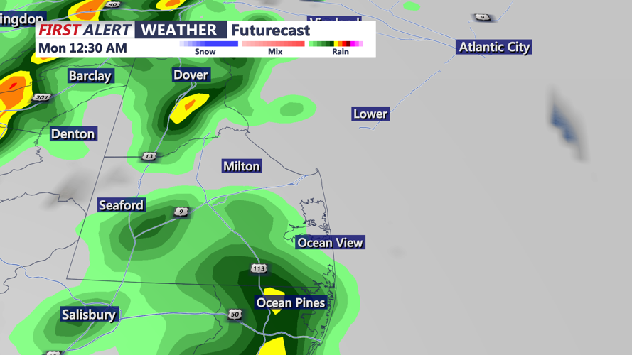


DELMARVA - A strong cold front will sweep across the region late Sunday night into early Monday morning, bringing showers, gusty winds, and a small risk of severe weather before temperatures cool and conditions stabilize to start the new workweek.
Most active period of weather will occur between midnight and 4 a.m. Monday as a narrow line of showers and isolated thunderstorms moves through the area. While widespread severe weather is not expected, the setup features a low-CAPE, high-shear environment capable of producing damaging wind gusts. Any storm that develops could mix stronger winds from aloft down to the surface, with gusts potentially strong enough to cause isolated damage.
There’s also a small chance of brief, weak tornadoes forming in this setup, with the greatest risk focused on the overnight hours when moisture and shear will be most favorable. The tornado risk remains around two percent for much of the area.
Once the cold front pushes east Monday morning, drier air will move in and showers will taper off. However, strong west to northwest winds will develop behind the front, gusting between 25 and 35 mph through the day. Temperatures will also take a noticeable dip — highs will be 10 to 15 degrees cooler than Sunday.
High pressure will briefly build into the Mid-Atlantic Monday night, calming winds and keeping conditions dry into early Tuesday. By Tuesday afternoon, another strong cold front will approach, bringing renewed chances for showers Tuesday night into early Wednesday, though rainfall amounts are expected to remain light.
Behind this system, another round of gusty winds is expected Wednesday as low pressure strengthens to the north.
The pattern remains unsettled into late week, with a weak front possibly moving through Thursday. While that system is expected to bring little to no rain, breezy conditions and increasing clouds will persist into Friday. High pressure is forecast to return Friday night into Saturday, setting the stage for a drier and calmer start to next weekend.