


DELMARVA - Even though winter-like temperatures have arrived on Delmarva this week, winter is still more than a month away.
But our meteorologists are already paying attention to what could potentially be a snowy winter here on the coast. In September, sea surface temperatures in the equatorial region were measuring above average, and atmospheric conditions indicated the presence of El Niño.
Sarah Johnson, Warning Coordination Meteorologist at the National Weather Service in Mt. Holly, New Jersey, noted, "We’ve been in El Niño since early this year, and that’s a change. The last three winters we were in La Niña, which was very unusual that we had three back-to-back La Niña winters."
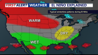
In a "neutral" year, the trade winds, which blow from east to west, push warm ocean water toward Asia.
During an El Niño year, there is a reverse effect. Trade winds weaken and push those warm waters toward South America instead.
The warmer waters cause the Pacific jet stream to move south of its neutral position.
This shift has ripple effects across the entire globe, but along the East Coast, we usually see a wetter-than-usual weather pattern.
When this wet pattern aligns with freezing temperatures in the atmosphere, we can expect snow here on Delmarva.
Meteorologist Sarah Johnson explained, "Looking back at previous El Niño years, it has produced some really big, impactful coastal storms in our area during the winter months."
However, there have also been El Niño years with very little winter weather.
El Niño is expected to continue into the spring of 2024.
Forecasters are calling for a thirty percent chance of a 'historically strong' El Niño event this winter. However, Delaware Emergency Management Agency (DEMA) officials do remind us to be prepared for any weather event, regardless of what the forecast says.