


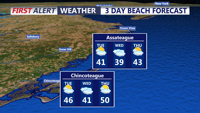
Today stays below average across Delmarva with partly sunny skies, highs in the upper 30s to low 40s, and a cold east-northeast wind off the ocean keeping conditions raw. Tonight turns partly cloudy with lows in the upper 20s to low 30s. The chill lingers Thursday before a warmer trend arrives Friday, the first day of spring, with highs near 60. Even warmer air builds in for the weekend, pushing temperatures into the 60s Saturday and low 70s inland Sunday before showers and cooler air return early next week.
From
To

Strong winds and sharply colder air will sweep into Sussex County and the beach towns Tuesday, with dry but blustery conditions lasting into early Wednesday.


Strong to severe storms, damaging wind gusts, minor bay flooding and rough marine conditions are expected from late Monday evening into late Tuesday evening in Sussex County and along the Delaware and Maryland beaches.


Today on Delmarva, a powerful storm system will bring the risk of strong to severe thunderstorms this afternoon into tonight, with damaging winds as the primary concern and an increasing threat for isolated tornadoes. Even outside of storms, southerly winds will gust from 35 to 45 mph, with some areas seeing gusts up to 50 mph. Heavy rainfall may lead to localized flash flooding, especially inland, while Sussex County faces minor coastal flooding along the back bays including Rehoboth Bay and Little Assawoman Bay. Conditions turn cooler and dry Tuesday through Wednesday before temperatures gradually moderate later in the week, with the next chance for showers arriving Friday night into Saturday.


Windy day on the way, with a threat for severe weather later today.


Windy start to the week with a threat for severe weather later Monday.

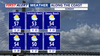
Sunday will turn a bit cloudier, but conditions remain pleasant with highs in the 50s and low 60s, and breezy conditions continue.


Today starts a much calmer pattern across Delmarva after several days of wild weather that included temperature swings, record highs, and accumulating snow. Skies will be mostly sunny with highs in the upper 40s to low 50s, though gusty south winds will ramp up this afternoon and evening to 35 to 40 mph. The weekend looks pleasant, with sunshine Saturday, more clouds Sunday, and temperatures warming into the upper 50s, 60s, and eventually near 70 by Monday ahead of a powerful cold front. That front could bring strong to severe thunderstorms Monday afternoon and evening, along with heavy rain and damaging wind gusts, before much colder air rushes back in for Tuesday and Wednesday.


Today across Delmarva, a powerful cold front is bringing a stunning turnaround in the weather, with temperatures crashing 40 to 50 degrees from yesterday’s record-breaking warmth. Rain showers will mix with and briefly change to wet snow late this afternoon for a few hours, with only a light coating possible on grassy and elevated surfaces while roads stay mostly wet. Gusty winds of 30 to 40 mph will add to the chill, sending wind chills into the upper 20s and low 30s by late day.