


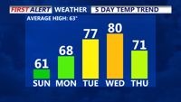
High pressure will maintain clear, dry, and sunny conditions across the Delmarva Peninsula through the beginning of the week. Expect seasonable temperatures on Sunday before a warming trend takes hold on Monday and Election Day. A weak cold front moving through midweek could bring some clouds and a slight chance of drizzle, with a return to cooler temperatures by Friday.
From
To

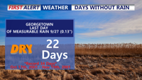
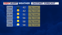
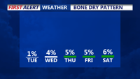
A prolonged dry spell continues across Delmarva as a warming trend sets in through the weekend and early next week. Today temperatures will reach the mid-to-upper 70s under clear skies, with slightly higher humidity. By early next week, temperatures could approach near-record highs in the low 80s, though coastal areas may remain cooler. While a cold front midweek brings a brief cooldown, significant rainfall remains unlikely, extending the already notable dry streak.

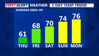
The chilly and dry weather continues the next couple of days, with a warm up into the weekend and especially next week. It remains dry

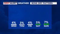
Strong high pressure over the eastern U.S. will keep Delmarva mostly dry and cool through Thursday, with breezy conditions and limited rain chances, despite a coastal low offshore.

Strong high pressure moving in from the Midwest will dominate Delmarva’s weather through Wednesday, maintaining dry and cool conditions with clear skies and patchy frost overnight.

A strong high-pressure system moving in from the Midwest will keep Delmarva dry and cool through midweek. Expect chilly overnight lows with patchy frost inland, followed by a crisp, sunny Wednesday with below-average temperatures.