


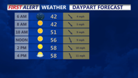


Expect a chilly start to the day as temperatures will be in the mid-30s for inland areas and around 40°F along the coast. The strong high pressure to our west will keep skies clear and winds light, allowing temperatures to rise slowly as the morning progresses. Frost may linger in some shaded areas, especially in rural parts of Delmarva, before gradually melting with the morning sun.
Wednesday Afternoon: Wednesday will feature abundant sunshine and calm conditions. Temperatures will peak in the low to mid-50s, similar to Tuesday’s highs, and below average for mid-October. A light northwest breeze around 5-10 mph will continue, but it won’t detract from an overall pleasant, if cool, day. Humidity levels will remain low, contributing to the crisp, fall-like feel across the area.
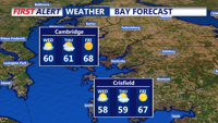
Outlook for the Rest of the Week: The high-pressure system will shift eastward by Wednesday night and Thursday, settling over our area by Friday and continuing into the weekend. This pattern will keep Delmarva dry and cool with clear skies through early next week. Expect chilly nights, mild afternoons, and continued potential for patchy frost in inland areas, especially under clear skies and calm winds.
The ongoing dry spell shows no sign of ending soon, with no rain in the forecast for the next several days.