


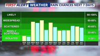
Sunday will deliver more summer warmth across Delmarva with highs in the 80s and only isolated thunderstorm chances. However, a cold front approaching Sunday night will trigger scattered showers and thunderstorms into early next week, followed by additional unsettled weather as stalled fronts linger and another system nears by the weekend.
From
To

Cooler, drier air arrives early Friday in Sussex County before temperatures and humidity climb again Saturday, with a risk of isolated severe storms.

A shift from high pressure to a slow-moving low will bring increasing chances of showers and thunderstorms to Sussex County from late Wednesday night through late Friday night, with locally heavy rainfall possible.

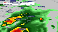
While severe storms remain west and south of the region, Delmarva starts the week under persistent cloud cover, patchy fog, and a low-end risk of isolated storms as a cold front approaches. Warmer, sunnier days are on the horizon by midweek.

A warm and unstable atmosphere moves into Delmarva on Sunday, bringing the chance of isolated storms, especially in southeastern areas. Highs will reach the mid-80s. A cold front passes through Sunday night, cooling temperatures into the 50s and 60s. High pressure builds in Monday, ushering in cooler and drier conditions through midweek. Uncertainty arises late in the week with a potential cold front and low-pressure system.

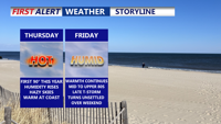
A cold front crossing Delmarva will bring cooler temperatures, reduced humidity, and a stretch of pleasant weather from Thursday night through Friday night.