


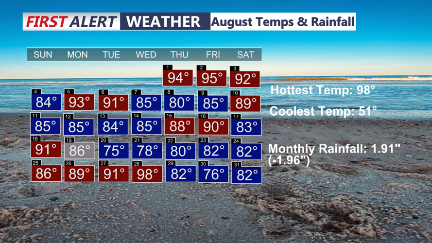

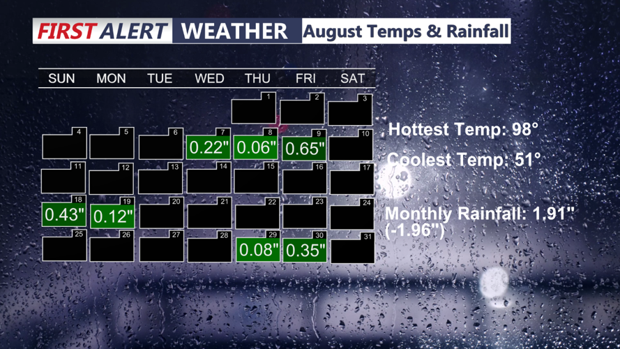


DELMARVA -- August certainly flew by, we ended the month with 17 days below average after starting the month quiet hot. We saw our hottest temperature of 98 degrees on August 28th and our lowest temperature of 51 degree on the morning of August 22nd.

In part it was a relatively dry month, we didn't see much in the way of rainfall. We ended the month with 1.92 inches of rain, that's 1.96 inches below normal. We now flip the calendar over to the month of September!

Today a boundary finally pushes northeast of Delmarva, allowing warmer and more conditionally unstable air to move in. Daytime highs will rise to the mid-80s across much of the region. While there is potential for significant weather, the best chances for storms will be confined to southeastern parts of the area, where upper-level forcing will be stronger. A stray severe storm is possible, but widespread severe weather is not expected. Storm Prediction Center maintains a "marginal" risk (1 out of 5).

Sunday night will bring primary and secondary fronts crossing the region. Any storms that develop near I-95 are expected to diminish quickly by early evening, though lingering showers could persist through the night in far southern areas where atmospheric forcing remains. These fronts won’t clear the southern parts of the region until around dawn on Monday. As cooler air moves in behind the fronts, lows will drop into the 60s.
Labor Day will be wonderful, high pressure will build out of the Great Lakes and move toward the Northeast and Mid-Atlantic regions. Expect a breezy but dry day, as the high pressure system remains to our west, creating a tight pressure gradient. This will mark the beginning of a stretch of cooler and less humid weather.
High pressure will settle over the Northeast and Mid-Atlantic on Tuesday and Wednesday, bringing dry conditions and less wind compared to Monday. Temperatures will continue to be cooler with comfortable humidity levels, offering a pleasant respite from recent heat.
By Thursday, the high pressure begins to shift northeast, offshore of New England and Canada, but will still influence Delmarva with dry conditions. Uncertainty grows toward the end of the week as a cold front approaches from the west, and a potential low-pressure system may lift northward from the south. Current models have shown variability in the path of this low, so we will maintain low-end chances of precipitation for Friday and Saturday as we monitor this evolving scenario.
