




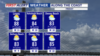
High pressure will keep the region dry from early Friday through Saturday morning, with warmer inland temperatures and cooler conditions near the coast.
From
To

High pressure will keep the region dry and mild late Thursday night before warmer temperatures arrive Friday.


Delmarva’s early taste of summer continues today as temperatures climb into the upper 80s to low 90s under mostly sunny skies. After Georgetown tied its record high of 87 yesterday, more record highs are possible today with southwest winds at 10 to 15 mph. The warmth holds through Thursday before a weak front slips through late Thursday night, followed by a cooler but still mild Friday and Saturday. A stronger cold front arrives Sunday with scattered showers and thunderstorms possible late, then much cooler air settles in early next week with highs dropping into the 50s and 60s and even a chance for frost by Tuesday morning.

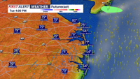
Sussex County is expected to stay warm and mainly dry from early Tuesday into early Wednesday, with only a limited chance of a passing late-day shower or storm Tuesday.


Delmarva starts the week on a warm and breezy note as a warm front lifts through the region, sending temperatures near 70 today and close to 80 Tuesday. Even warmer air builds in Wednesday, with record highs potentially challenged inland before a cold front brings the chance for afternoon and evening showers and thunderstorms. That front may stall nearby, keeping the weather unsettled through the weekend with periodic shower chances, but no day looks like a washout.

"Delmarva will enjoy unseasonably warm and sunny weather on Wednesday, with highs near 80 degrees and gusty southwest winds, before a cold front brings a slight chance of showers and cooler temperatures by evening."