


This morning, expect skies to gradually clear with areas of fog, with temperatures in the 40s.
From
To

Delmarva stays locked in arctic cold today with highs only in the low to mid 20s under increasing clouds, flirting with record territory near Georgetown. Light snow and flurries arrive this evening and overnight, with the best chance for measurable snow remaining in far southern and coastal areas, especially Accomack County. The bigger story is a rapidly strengthening storm offshore that will bring bitter wind chills and the risk of minor coastal flooding during the Sunday morning high tide


Gov. Wes Moore and members of the Delaware Senate Majority Caucus are criticizing the Trump administration’s push to revoke federal approval for the U.S. Wind offshore project near Ocean City, calling it a short-sighted move that threatens jobs and clean energy progress.

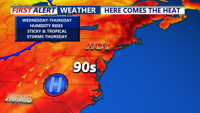
This afternoon we'll see warm and muggy conditions under partly sunny skies. Temperatures will top out in the mid to upper 80s. With the humidity it will feel like mid 90s.

High pressure remains offshore through Tuesday with mild conditions and a weak cold front bringing light showers Tuesday afternoon, followed by more active weather later in the week

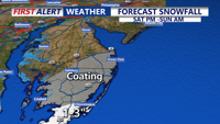
A developing low-pressure system will bring a mix of snow, rain, and freezing rain to the region from Saturday into early Sunday before conditions improve later in the day.

A second cold front will bring breezy conditions late Thursday into Friday before a high-pressure system briefly settles over the region.

High pressure moving offshore will bring record warmth to Delmarva through Tuesday night, with temperatures remaining mild overnight. A cold front will arrive by late Wednesday, bringing cooler air and increased winds as the region heads into Thursday.


A secondary coastal low will bring scattered showers to Delmarva late tonight, with the heaviest rain staying offshore on Wednesday.

A high-pressure system currently over the Delmarva Peninsula will keep temperatures below normal through tonight, with clear and cool conditions expected. As this high pressure moves offshore into the weekend, temperatures will rebound to near-normal levels. By early next week, an approaching weather system will bring increased chances for showers and thunderstorms.