


DELMARVA - A second cold front will bring breezy conditions late Thursday into Friday before a high-pressure system briefly settles over the region. Another low-pressure system is expected to bring a mix of rain and snow Friday night into Saturday before clearing out by early Sunday.
A second cold front is set to move across the region late Thursday night into Friday morning, bringing a shift in conditions. Patchy fog, particularly dense in parts of Delmarva and South Jersey, will linger overnight before the front arrives around midnight. A few isolated showers are possible in southern Delmarva and far South Jersey, but precipitation is expected to be minimal. Behind the front, drier air will move in, leaving behind mostly mid- and high-level cloud cover. Overnight lows will dip into the 30s.
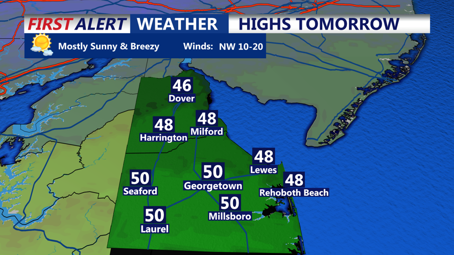
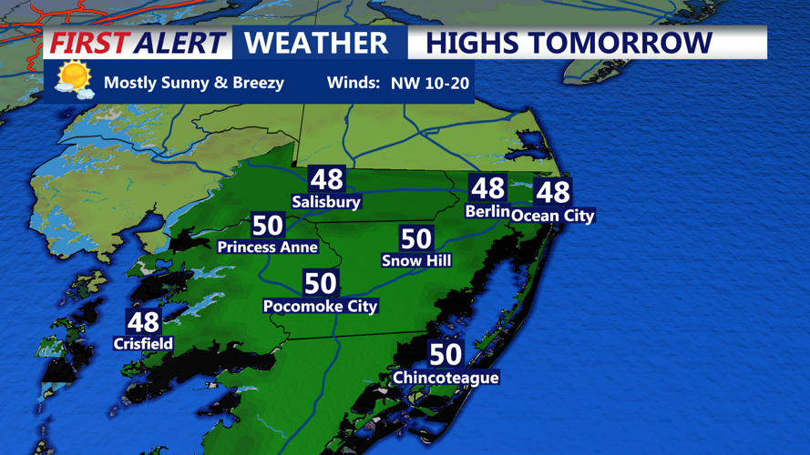
By late Friday morning, a secondary cold front will push through, bringing gusty northwest winds. Wind speeds will range between 20 and 30 mph, with gusts reaching up to 40 mph in higher elevations, particularly in the Poconos. Skies will be a mix of sun and clouds, with temperatures near seasonal averages—mid to upper 30s in areas north of Philadelphia and low to mid-40s farther south. Winds will taper off by the afternoon as high pressure builds in.
Friday night will be dry and colder, with overnight temperatures falling into the teens and 20s. However, changes will arrive by Saturday morning as a low-pressure system develops over the mid-Mississippi Valley and moves eastward. This system will spread light snow across southern portions of the region in the morning, with a wintry mix, including freezing rain, expanding northward through the afternoon. By Saturday night, coastal and southern areas of New Jersey and Delmarva will likely transition to plain rain, while regions northwest of the I-95 corridor will experience a mixture of snow, sleet, and freezing rain.
Precipitation will begin tapering off early Sunday as the system pulls offshore. The final storm totals will likely be similar to the previous system, though this one is expected to bring a more prolonged period of wintry mix across the northern two-thirds of the region, with increased snowfall potential for the southern Poconos and northwestern New Jersey.
Sunday afternoon is expected to be mostly dry with seasonable temperatures and a mix of sun and clouds. While high pressure will temporarily settle over the region, an active weather pattern is expected to continue into next week, with additional storm systems possible on Tuesday into Wednesday and again on Thursday.
