




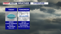
Mostly cloudy skies, areas of fog, and occasional showers or drizzle will linger across Delmarva today as a stationary front nearby begins to lift north as a warm front. Temperatures will slowly rise overnight, and noticeably milder weather is expected this weekend and into early next week, with several additional chances for showers.
From
To

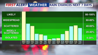
A developing coastal storm is bringing periods of rain and gusty winds to Delmarva beginning Wednesday afternoon, with temperatures stuck in the 50s. The unsettled pattern continues into Thursday before tapering into scattered showers Friday. A gradual clearing trend and slightly warmer weather is expected over the weekend, though cooler-than-average temperatures persist.

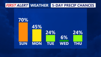
A rainy Sunday afternoon across Delmarva marks the start of a multi-day stretch of unsettled weather driven by a slow-moving upper-level low over the Ohio Valley. While conditions improve briefly midweek, another cold front and trough system may bring showers and cooler air back by Friday before high pressure builds in for the weekend.


Rain and downpours return to Delmarva Sunday with a stretch of unsettled weather lasting into Tuesday as multiple waves of energy track through the region. While conditions briefly dry out by midweek, another cold front and upper-level system will bring more showers and cooler temperatures before the weekend.

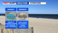
Scattered showers and storms with highs in the low to mid 70s Sunday. A mild, humid weekend transitions into a wet and cooler start to the workweek across Delmarva, with periods of heavy rain and thunderstorms expected through Tuesday. A cooler, more stable pattern begins to emerge by the end of the week.

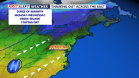
Delmarva is set to experience a noticeable thaw in the final week of February. Kicking off with a chilly Sunday night featuring temperatures in the upper 20s to low 30s under mostly cloudy skies, the forecast then shifts to abundant sunshine on Monday with highs in the low 50s. As the week progresses, increasing southerly flow brings even milder conditions—with Tuesday reaching into the low 60s. Later in the week, a low pressure system moves in from the Ohio Valley, introducing chance precipitation that will be in the form of rain, before fair weather returns Friday and into early next weekend.