


DELMARVA -- Our weather takes a brisk turn tonight as temperatures drop into the upper 20s to low 30s across much of the peninsula. Expect mostly cloudy skies to prevail, setting a cool backdrop before the warming trend begins.
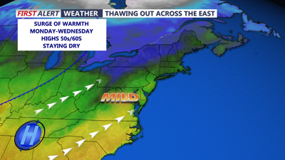
With plenty of sunshine forecast for Monday, you can look forward to a welcome rise in temperatures, with highs reaching the low 50s. This burst of sunlight will kick-start the thawing process, ensuring a noticeable improvement from tonight’s chill.
As southerly winds increase and cloud cover becomes more scattered, Monday night promises a milder environment. Most areas are expected to remain above freezing, providing a gentle reprieve from the earlier cool conditions.
Tuesday marks an even more encouraging day for Delmarva, with temperatures surging well into the low 60s. The overall warming trend continues, setting the stage for a noticeably thawed atmosphere as the peninsula moves toward a more seasonal spring-like feel.
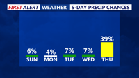
While high pressure dominates the early part of the week, it begins to weaken as an upper trough heads toward the upper Great Lakes. This trough will eventually promote the formation of a low pressure system in the Ohio Valley, which is forecast to move east-northeast across the Middle Atlantic by Thursday. Along with this system, there will be chances for precipitation—mainly rain for most areas. Although temperatures will be above normal on Wednesday and Thursday, a cold front arriving later on Thursday is expected to nudge conditions back closer to the seasonal norms by Friday.

Looking dry through at least Thursday, ahead of a cold front that can bring rain to the area.
Despite the midweek disturbance, fair weather is anticipated to return later Friday and extend into the early part of next weekend. Overall, the forecast indicates a steady thaw, with temperatures climbing steadily through Tuesday and then experiencing only minor adjustments later in the week.