


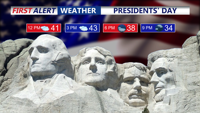
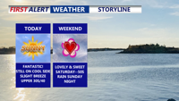
The rain has ended across Delmarva, with drier, breezy, and chilly conditions on tap for Presidents' Day.
From
To

The soaking rain tapers off late tonight, then a breezy, drier, and chilly Presidents' Day.

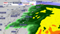
Low pressure slides to our south later today into early Monday morning bringing a soaking rain.

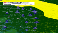
Low pressure slides to our south late Sunday into early Monday morning bringing a soaking rain.

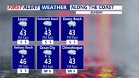
Delmarva gets a wall-to-wall sunny Friday but it stays about 10° below average with northwest wind gusts up to 20 mph. Tonight turns clear and cold, dropping into the low to mid 20s. Valentine’s Day looks lovely with mostly sunny skies and highs in the upper 40s to low 50s. Clouds increase late Saturday night and Sunday turns cloudy, topping out in the mid to upper 40s. Early next week, confidence is rising in a warmer, faster system favoring the coastal plain, bringing mainly rain

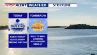
Delmarva stays breezy and brisk today as northwest winds gust 20 to 25 mph, making mid to upper 30s feel closer to the 20s. Winds ease tonight into Friday under building high pressure with clear, colder nights and sunny skies. Temperatures rebound this weekend, with near-50 warmth possible Saturday and seasonably mild readings Sunday. A low pressure system passing to the south late Sunday into Monday may bring a period of precipitation, with rain favored overall but a low-probability scenario that could allow some inland snow if the storm strengthens and pulls colder air into the region.

Today brings a noticeable thaw across Delmarva with highs in the upper 40s to low 50s, but it stays blustery with northwest gusts up to 35 mph. Cooler, breezy weather returns Thursday and Friday, followed by a beautiful Valentine’s Day near 50 degrees. Attention then turns to a potential storm late Sunday into Monday, with track and impacts still uncertain.