


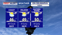


DELMARVA -- The thaw continues across the Delmarva Peninsula as temperatures climb into the upper 40s to low 50s.

The thaw continues on Delmarva with highs in the upper 40s to near 50.
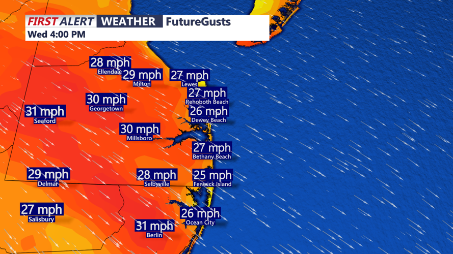
It won’t feel perfectly mild for long, though, thanks to a brisk northwest wind that will stay active through the day with gusts around 30 to 35 mph.

Gusts 30-35 mph out of the northwest through the afternoon-evening.
Skies will trend mainly sunny, and by this evening those winds ease while temperatures drop quickly.
Tonight will be mainly clear and much colder, with lows falling back into the upper 20s. That sets the stage for a cooler stretch to finish the workweek. Thursday will be breezy and partly sunny with highs in the upper 30s, followed by wall-to-wall sunshine on Friday with highs near 40.
Looking ahead to the weekend, Valentine’s Day is shaping up to be a standout: plenty of sun and highs near 50 degrees for a sweet, springlike feel on Delmarva. After that, all eyes turn to a developing storm system that could approach late Sunday into Monday.

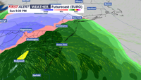
Keep eyes on a possible storm system impacting the area late Sunday-Monday morning that could bring rain, wind and possibly wet snow.
Forecast confidence decreases for late weekend into early next week. Model guidance continues to show an area of low pressure affecting the eastern seaboard from later Sunday into Monday, but there remains uncertainty in the system’s intensity, timing, and exact track. Recent trends in much of the guidance have nudged the storm farther south and east, which would mean less impact for Delmarva. However, one model is an outlier showing a stronger, farther-north solution that could bring more widespread precipitation Sunday night into Monday, tied to better “phasing” between northern and southern energy streams.
With a relatively mild air mass in place ahead of the system (Saturday highs generally upper 40s to low 50s), rain is favored for most areas if precipitation arrives, or a brief mix that changes to rain. In the lower-probability, colder outlier scenario, the setup could generate just enough cold air for accumulating snow inland, while the immediate coast would be less likely to see meaningful snow. Updates are expected as the storm track becomes clearer over the next few days.
