


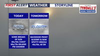
A stalled front keeps Delmarva dreary and foggy today, with the coolest, foggiest weather hugging the coast while inland areas briefly break into sunshine and warmer temperatures. Fog and drizzle linger into tonight and early Friday, then a backdoor cold front reinforces cooler, cloudier conditions. The pattern flips this weekend as warmer air pushes back in, turning noticeably milder Sunday and especially early next week with a few chances for showers and even a thunderstorm.
From
To


A shift to a southerly flow will bring warmer temperatures and mostly dry conditions to Delmarva on Monday and Tuesday, with highs reaching the low to mid-70s before a weak cold front approaches midweek.

A warm and dry pattern continues for Delmarva, with high pressure maintaining clear skies and unseasonably warm temperatures through Thursday. A cold front will bring a slight chance of rain early Friday, followed by a cooler weekend before temperatures warm again next week.

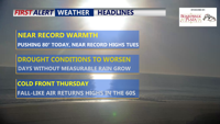
High pressure will dominate Delmarva's weather through Wednesday, bringing clear skies, warm afternoons, and cool nights. Temperatures will rise near record highs by Tuesday, followed by a significant cold front late Wednesday night into Thursday morning. Cooler, breezy conditions will settle in for Thursday and Friday. Another cold front is expected on Saturday, followed by high pressure and seasonal weather for the weekend.


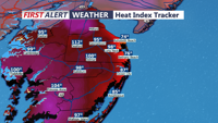
The expected Tuesday highs will not challenge the record temperature for Sussex County. According to the National Oceanic and Atmospheric Administration, Millsboro set the Delaware record with a 110 degree reporting on July 21, 1930. It was also on the same date that Salisbury experienced its all-time high of 106 degrees.

A weak front will keep Delmarva warm and humid through Tuesday, with a cold front approaching mid-week.