


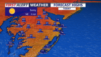
Delmarva will enjoy sunny, dry weather today through the end of the week as high pressure remains in control. Inland temperatures will climb from the upper 70s and low 80s today into the low 90s by Friday and Saturday, while beaches stay cooler thanks to sea breezes. A cooler, unsettled pattern arrives late this weekend into early next week with showers and thunderstorms possible.
From
To


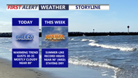
A much warmer pattern is taking over across Delmarva this weekend and will continue into the middle of next week.

A much warmer pattern is taking over across Delmarva this weekend and will continue into the middle of next week.


Sussex County, Delaware, is expected to stay very warm from early Wednesday morning through early Thursday morning, with only a slight and uncertain chance of an afternoon or evening thunderstorm Wednesday.


A few thunderstorms could reach Sussex County late Tuesday evening before weakening overnight, while Wednesday brings very warm temperatures and a low-confidence chance of isolated afternoon or evening storms.

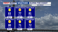
A warm Monday night will give way to a dry, breezy and unusually warm Tuesday, with inland areas of Sussex County heating up much more than beach towns from Lewes to Ocean City.

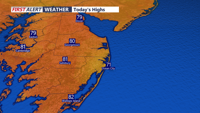
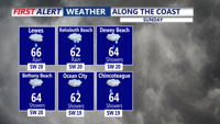
Today brings a pleasant and mild start to the week across Delmarva with mostly cloudy skies, breezy southwest winds, and highs near 80 inland, while beach communities stay in the mid to upper 70s. A weak disturbance could spark an isolated light shower, mainly north and west of the peninsula. Warmer air then builds in through midweek and into the weekend, sending temperatures 15 to 30 degrees above average with some inland spots potentially reaching 90 degrees for the first time this year.


This morning, expect skies to gradually clear with areas of fog, with temperatures in the 40s.


Any shower activity will end early this evening as a cold front moves through the region.

A weakening cold front may still bring scattered showers and perhaps even a thunderstorm this afternoon and evening.