


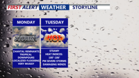
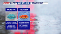
Starting Monday, Delmarva will enter a prolonged stretch of hot, humid, and stormy weather. The remnants of Tropical Storm Chantal will bring widespread showers and thunderstorms capable of downpours and localized flooding. Even the threat for severe storms Tuesday. As the week progresses, a stalled front and several disturbances will prolong unsettled conditions, with dangerous heat indices nearing 106 degrees and repeated rounds of storms expected into the weekend
From
To

A stalled front over Delmarva Sunday will trigger heat and isolated storms to start the week. By Tuesday, a stronger cold front will bring the chance of severe thunderstorms. High pressure then builds in midweek, setting up lower humidity and comfortable weather heading into the Fourth of July holiday weekend.

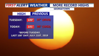
A second consecutive day of record-breaking heat on Delmarva peaked at 101 degrees in Georgetown on Wednesday, surpassing a decades-old high. The intense heat persists into Thursday with dangerous heat indices, but relief is in sight as a backdoor cold front ushers in cooler conditions and elevated storm chances heading into the weekend.

Delmarva begins the week with damp, gray skies and cooler temperatures, but change is on the horizon. After periods of drizzle and light showers Monday and Tuesday, warmer and more humid air arrives midweek. By Thursday, temperatures could soar into the 90s with strong to severe storms possible as a cold front sweeps through. The weekend looks drier and more comfortable with sunshine and highs in the 80s.


While severe storms remain west and south of the region, Delmarva starts the week under persistent cloud cover, patchy fog, and a low-end risk of isolated storms as a cold front approaches. Warmer, sunnier days are on the horizon by midweek.


A powerful storm system is set to bring heavy rain, potential flooding, and strong thunderstorms to Sussex County from late Friday through Saturday evening.