


DELMARVA -- A weak cold front will stall across Delmarva early Sunday, keeping conditions unsettled in the southern half of the peninsula. Any patchy fog or mist should burn off quickly after sunrise.

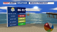
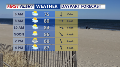
Mostly sunny, highs upper 80s to low 90s, isolated t-storm, MODERATE risk of rip currents.
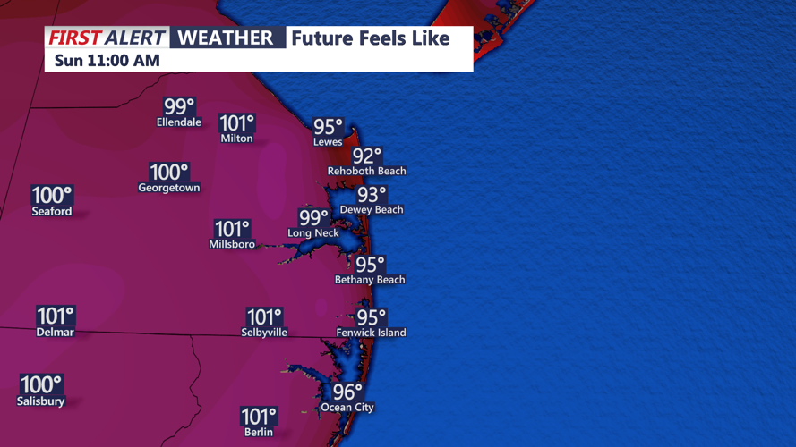
Northern Delmarva will enjoy mostly sunny skies, while areas closer to the front in the south will see partly sunny conditions with isolated to scattered showers and thunderstorms possible by afternoon. Temperatures will climb into the upper 80s and low 90s, and interior areas will contend with oppressive heat index values between 100 and 104 degrees.

Could once again see triple digit heat indices away from the coast Sunday afternoon.
A few showers may linger in the southern counties after sunset, but most of the region will be dry. Overnight will stay muggy, with lows in the mid to upper 60s north and low 70s south.

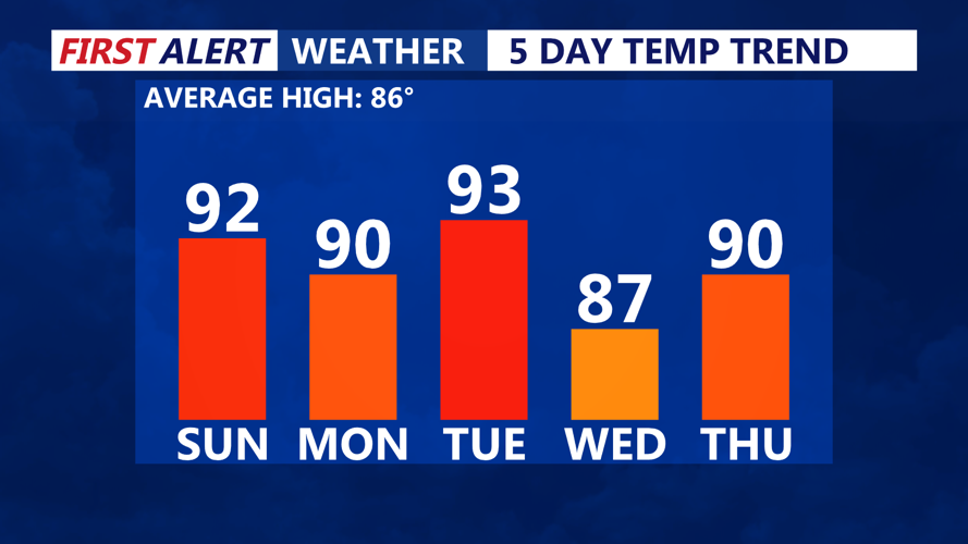
Hovering around low 90s, slightly cooler Wednesday with lower humidity.
An upper-level trough moving east out of the Midwest will help push the stalled front back north as a warm front. This boundary will bring another round of scattered showers and thunderstorms, with the best chance (40–60%) focused across southern and western areas of Delmarva. Temperatures will again approach 90 degrees, and rising dew points will keep heat indices elevated. The mugginess will linger into Monday night, when lows remain warm in the mid to upper 70s.
Tuesday looks to be the most active weather day of the week. As the upper-level trough amplifies over the Northeast, a strong cold front will approach the region by late afternoon. Ahead of this boundary, moderate instability could develop in combination with strengthening wind shear, especially farther north toward Pennsylvania and New Jersey. If the timing aligns, there is potential for strong to severe thunderstorms capable of producing damaging winds. Highs will reach the mid-80s to near 90 degrees depending on cloud cover and storm development. While humid, no extreme heat is forecast. This is the day to watch closely for severe weather potential.
By late evening, the cold front is expected to sweep offshore, ending the storms around midnight. Overnight temperatures will dip a few degrees cooler, with lows in the upper 60s and low 70s.
Behind the front, an upper-level trough will linger over the Mid-Atlantic. While temperatures will not fall much, the dew points will drop into the 60s, bringing noticeably more comfortable air. With limited moisture and surface high pressure building in, shower chances look low, and most areas will stay dry with pleasant summer weather.
High pressure becomes better established over Delmarva Friday. Although a warm front will begin to lift northeast well to the west of the region, any associated rain chances should stay away for now. Highs will be in the upper 80s with lower humidity—ideal for early holiday plans. The forecast currently favors continued nice weather through the Fourth of July and into the weekend.